IMAGES TAKEN NEAR TO
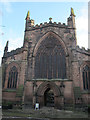
Church Walk, NANTWICH, CW5 5RG
Introduction
This page details the photographs taken nearby to Church Walk, CW5 5RG by members of the Geograph project.
The Geograph project started in 2005 with the aim of publishing, organising and preserving representative images for every square kilometre of Great Britain, Ireland and the Isle of Man.

There are currently over 7.5m images from over14,400 individuals and you can help contribute to the project by visiting https://www.geograph.org.uk
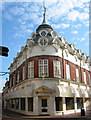
Image Map
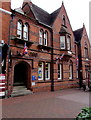
Images are licensed for reuse under creativecommons.org/licenses/by-sa/2.0
Notes
- Clicking on the map will re-center to the selected point.
- The higher the marker number, the further away the image location is from the centre of the postcode.
Image Listing (532 Images Found)
Images are licensed for reuse under creativecommons.org/licenses/by-sa/2.0
Image
Details
Distance
1
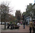
Church and town square - Nantwich, Cheshire
A view from the town square towards the west end of St Mary's Church - building started in 1388 and it is known as the cathedral of South Cheshire. Time taken 11.34 am BST (British Summer Time).
Image: © Martin Richard Phelan
Taken: 4 May 2013
0.00 miles
2
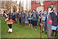
Holly Holy Day, Nantwich
Parliamentary troops of the Sealed Knot at the wreath laying ceremony in the town square during Holly Holy Day. St Mary's Church can be seen in the background.
Holly Holy Day commemorates the lifting of the Siege of Nantwich during the English Civil War on 25th January 1644, the name is derived from the locals wearing sprigs of holly in their hats to celebrate.
Image: © Jeff Buck
Taken: 24 Jan 2015
0.00 miles
3
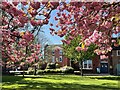
St Mary's churchyard
There are some fine Georgian buildings around the grassy churchyard, framed beautifully at this time of year by the cherry blossom.
Image: © Mike Parker
Taken: 25 Apr 2023
0.00 miles
4

Nantwich Musketeer
A member of the Sealed Knot displays the equipment of a musketeer outside St Mary's Church as part of Nantwich's Holly Holy Day.
Holly Holy Day commemorates the lifting of the Siege of Nantwich during the English Civil War on 25th January 1644 and the name is derived from the locals wearing sprigs of holly in their hats to celebrate.
Image: © Jeff Buck
Taken: 24 Jan 2015
0.01 miles
5
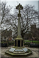
Nantwich War Memorial
Unveiled 1921
https://www.iwm.org.uk/memorials/item/memorial/2048
Image: © Brian Deegan
Taken: 3 Mar 2018
0.01 miles
6
Domed building (view SW)
An unusual grade-II-listed building by E H Edleston, dated 1911, with round windows and a dome, located on the corner of Hospital Street and Pillory Street, near the town square. Currently used as a shop. See also Image
Image: © Espresso Addict
Taken: 29 Oct 2006
0.01 miles
7
TSB Nantwich
Bank branch at 1-3 Churchyardside.
Image: © Jaggery
Taken: 13 Oct 2016
0.01 miles
8
St Mary, Nantwich: west end
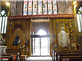
The west end of the church shows the red sandstone from which it is built, which apparently came from a quarry near the Dee estuary. The west doors are now kept permanently open, with an inner glazed screen giving views into the church.
Image: © Stephen Craven
Taken: 30 Dec 2016
0.02 miles
9
St Mary, Nantwich: Jubilee curtain
This large curtain was made to celebrate the Silver Jubilee of Queen Elizabeth II in 1977, and covered the whole width of the narthex until 2016 when the decision was made to permanently open the main west doors, with a glazed screen inside them to allow passers-by to see into the church. The curtain has therefore been drawn aside to facilitate this.
Image: © Stephen Craven
Taken: 30 Dec 2016
0.02 miles
10

The Parish Church of St Mary
Approaching the church from the west, considered by some to be one of the finest medieval churches, not only in Cheshire, but in the whole of England.
Image: © Eirian Evans
Taken: 27 Jul 2012
0.02 miles