IMAGES TAKEN NEAR TO
James Hall Street, NANTWICH, CW5 5QE
Introduction
This page details the photographs taken nearby to James Hall Street, CW5 5QE by members of the Geograph project.
The Geograph project started in 2005 with the aim of publishing, organising and preserving representative images for every square kilometre of Great Britain, Ireland and the Isle of Man.

There are currently over 7.5m images from over14,400 individuals and you can help contribute to the project by visiting https://www.geograph.org.uk
Image Map
Images are licensed for reuse under creativecommons.org/licenses/by-sa/2.0
Notes
- Clicking on the map will re-center to the selected point.
- The higher the marker number, the further away the image location is from the centre of the postcode.
Image Listing (61 Images Found)
Images are licensed for reuse under creativecommons.org/licenses/by-sa/2.0
Image
Details
Distance
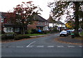
1
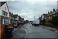
Weaver Road
Looking along Weaver Road in Nantwich on a wet day.
Image: © DS Pugh
Taken: 6 Aug 2023
0.04 miles
2
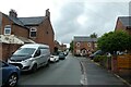
Hurleston Buildings
Looking along a street leading to Barony Road in Nantwich.
Image: © DS Pugh
Taken: 6 Aug 2023
0.05 miles
3
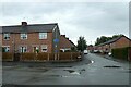
Weaver Road meets Prince Edward Street
National Cycle Network route 451 runs along here.
Image: © DS Pugh
Taken: 6 Aug 2023
0.08 miles
4
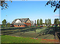
Recreational ground near The Barony: facilities
Tennis courts, pavilion and children's playground off Barony Road. There are also five-a-side pitches, bowling green and a skate/bike park
Image: © Espresso Addict
Taken: 9 Oct 2006
0.10 miles
5
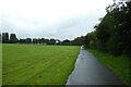
Path along the edge of the Barony
The path is part of National Cycle Network route 451.
Image: © DS Pugh
Taken: 6 Aug 2023
0.12 miles
6
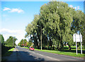
Middlewich Road (A530), N Nantwich
Broad road on the outskirts of Nantwich. The recreational grounds at The Barony are on the right, St Mary's Cemetery and the retail park on Beam Heath Way are on the left
Image: © Espresso Addict
Taken: 9 Oct 2006
0.15 miles
7
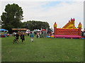
North West Triathlon, bouncy castle (for spectators)
This triathlon is a great spectator event, particularly for the families of competitors. At the swimming pool you can get into the side of the pool, in the park there are amusements like this bouncy castle, food stalls, and a shop for triathlon equipment. There is plenty of car parking at one end of the park.
Image: © David Hawgood
Taken: 5 Sep 2010
0.16 miles
8
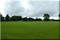
The Barony
Looking across playing fields from part of National Cycle Network route 451.
Image: © DS Pugh
Taken: 6 Aug 2023
0.16 miles
9
Volunteer Fields, Nantwich
Road on the north side of Beam Street. One source states that this area was where
local volunteers gathered to enlist to fight in the Napoleonic Wars in the early 19th century.
Image: © Jaggery
Taken: 26 Oct 2016
0.16 miles
10

Lady Helen Walk, Nantwich
Cul-de-sac on the north side of Beam Street.
Image: © Jaggery
Taken: 26 Oct 2016
0.16 miles