IMAGES TAKEN NEAR TO
NANTWICH, CW5 5BS
Introduction
This page details the photographs taken nearby to CW5 5BS by members of the Geograph project.
The Geograph project started in 2005 with the aim of publishing, organising and preserving representative images for every square kilometre of Great Britain, Ireland and the Isle of Man.

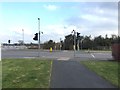
There are currently over 7.5m images from over14,400 individuals and you can help contribute to the project by visiting https://www.geograph.org.uk
Image Map
Images are licensed for reuse under creativecommons.org/licenses/by-sa/2.0
Notes
- Clicking on the map will re-center to the selected point.
- The higher the marker number, the further away the image location is from the centre of the postcode.
Image Listing (32 Images Found)
Images are licensed for reuse under creativecommons.org/licenses/by-sa/2.0
Image
Details
Distance
1
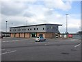
Nantwich: Weaver Stadium
The Weaver Stadium is the home of Nantwich Town FC, who play in the Evo-Stik League. The Weaver is the river which runs through Nantwich.
Image: © Jonathan Hutchins
Taken: 15 Mar 2015
0.00 miles
2
Nantwich: Weaver Stadium
As seen from Henhull FP4. The Weaver Stadium is the home of Nantwich Town FC, who play in the Evo-Stik League.
Image: © Jonathan Hutchins
Taken: 15 Mar 2015
0.00 miles
3
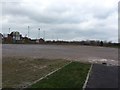
Nantwich: overflow car parking at the Weaver Stadium
The Weaver Stadium is the home of Nantwich Town FC who play in the Evo-Stik League.
Image: © Jonathan Hutchins
Taken: 15 Mar 2015
0.05 miles
4
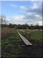
Nantwich: footpath Nantwich FP5
Helpfully duckboarded, Nantwich FP5 passes the east side of the Weaver Stadium and its car park to join Waterlode.
Image: © Jonathan Hutchins
Taken: 15 Mar 2015
0.06 miles
5
Nantwich: pedestrian crossing on Waterlode
Here footpath Nantwich FP5 crosses Waterlode into a large mock-Georgian housing development.
Image: © Jonathan Hutchins
Taken: 15 Mar 2015
0.11 miles
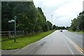
6
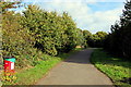
Cycle path along Water Lode
The path is part of National Cycle Network route 551.
Image: © DS Pugh
Taken: 6 Aug 2023
0.12 miles
7
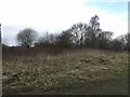
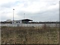
Kingsleyfield Farm (site of)
The current 2.5" OS map shows two small buildings here labelled 'Kingsleyfield Farm'. Nothing remains except some scanty footings.
Image: © Jonathan Hutchins
Taken: 15 Mar 2015
0.13 miles
8
Path on the east side of Waterlode, Nantwich
From the B5341 Waterlode towards Manor Road.
Image: © Jaggery
Taken: 26 Oct 2016
0.13 miles
9

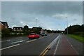
Path signpost alongside the B5341 Waterlode, Nantwich
Showing a quarter of a mile to Manor Road and one mile to Reaseheath College, the signpost arm points towards this path. http://www.geograph.org.uk/photo/5172617 The presence of a stile suggests that a locked gate used to be where the metal barrier is now.
Image: © Jaggery
Taken: 26 Oct 2016
0.14 miles
10
Junction of cycle paths
Looking along Water Lode. The path ahead is part of National Cycle Network route 551 with the one to the left part of 451.
Image: © DS Pugh
Taken: 6 Aug 2023
0.14 miles