IMAGES TAKEN NEAR TO
Castle Street, NANTWICH, CW5 5BA
Introduction
This page details the photographs taken nearby to Castle Street, CW5 5BA by members of the Geograph project.
The Geograph project started in 2005 with the aim of publishing, organising and preserving representative images for every square kilometre of Great Britain, Ireland and the Isle of Man.

There are currently over 7.5m images from over14,400 individuals and you can help contribute to the project by visiting https://www.geograph.org.uk
Image Map
Images are licensed for reuse under creativecommons.org/licenses/by-sa/2.0
Notes
- Clicking on the map will re-center to the selected point.
- The higher the marker number, the further away the image location is from the centre of the postcode.
Image Listing (529 Images Found)
Images are licensed for reuse under creativecommons.org/licenses/by-sa/2.0
Image
Details
Distance
1
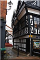
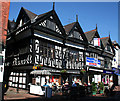
Nantwich: Castle Street
Traffic can get up Castle Street as far as the bollard, but is then turned back before it can enter the pedestrianized High Street.
When I first knew Nantwich the situation was reversed: through traffic passed along the High Street, off which Castle Street was a short dead-end, and the only access to properties on the little street was down this narrow entrance. The construction of Nantwich's inner ring road, Water Lode, along the banks of the Weaver in the late 1970s, opened up the waterside and formerly dead-end entries such as Castle Street or the nearby Mill Street changed their orientation completely.
An image of the same building a little over 50 years previously can be seen at Image
Image: © Christopher Hilton
Taken: 16 Feb 2015
0.02 miles
2
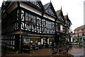
Nantwich: half-timbered buildings on the Square
Image: © Christopher Hilton
Taken: 16 Feb 2015
0.02 miles
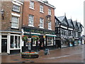
4
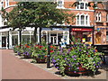
High Street, Nantwich
This view looking north west along High Street Nantwich shows the historic Crown Hotel noted for its long gallery along its top floor.
Image: © Colin Park
Taken: 7 Mar 2010
0.02 miles
5
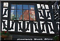
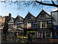
42-46 High Street on a sunny early morning
Nantwich Bookshop opened a coffee shop a few years ago, and now has tables outside. The timber-framed building dates from after the fire of 1583 and has some of the finest decorative timberwork in the town centre. The bookshop (left two gables) is listed at grade II*; the charity shops (right two gables) are listed at grade II
Image: © Espresso Addict
Taken: 16 Jun 2010
0.03 miles
6
Three centuries meet
Reflections in the window of the Elizabethan 46 High Street show the 19th century building opposite and some 21st century scaffolding. The timberwork is decorative framing; the downward sag on the first floor is very obvious in this close up
Image: © Espresso Addict
Taken: 12 Jun 2010
0.03 miles
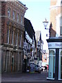
7
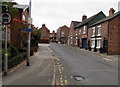
Mill Street, Nantwich
East along Mill Street from the corner of the B5341 Waterlode
looking towards Barker Street and the Wickstead Arms pub.
Image: © Jaggery
Taken: 13 Oct 2016
0.03 miles
9
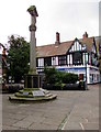
Nantwich War Memorial
Located in High Street, the Memorial is a stone calvary on an octagonal base.
Image: © Jaggery
Taken: 13 Oct 2016
0.03 miles
10
42-44 High Street, Nantwich
This half-timbered building is one of many in Nantwich town centre. It is listed grade 2 (list entry 1138692) and is described as being built after the fire of 1583, with 19th century bay windows to one side and modern shop frontages below, which currently host a bookshop, cafe and charity shop. See also Image
Image: © Stephen Craven
Taken: 30 Dec 2016
0.03 miles