IMAGES TAKEN NEAR TO
Cranage Wood, CREWE, CW4 8HP
Introduction
This page details the photographs taken nearby to Cranage Wood, CW4 8HP by members of the Geograph project.
The Geograph project started in 2005 with the aim of publishing, organising and preserving representative images for every square kilometre of Great Britain, Ireland and the Isle of Man.

There are currently over 7.5m images from over14,400 individuals and you can help contribute to the project by visiting https://www.geograph.org.uk
Image Map
Images are licensed for reuse under creativecommons.org/licenses/by-sa/2.0
Notes
- Clicking on the map will re-center to the selected point.
- The higher the marker number, the further away the image location is from the centre of the postcode.
Image Listing (5 Images Found)
Images are licensed for reuse under creativecommons.org/licenses/by-sa/2.0
Image
Details
Distance
1
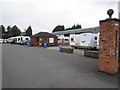
Inside Spinney's gates
Where the discerning motorhomer can find succour, supplies and support.
Image: © Peter Turner
Taken: 1 Aug 2011
0.18 miles
2
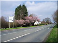
Road Junction of B5082 to Northwich on the A50
B5082 to Northwich on the A50 is sign posted just before the road junction.
Image: © R Greenhalgh
Taken: 24 Mar 2007
0.20 miles
3
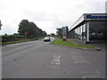
Outside Spinney's
On the A50 outside a local dealer in motorhomes and caravans, equally inconvenient for the surrounding conurbations of the Potteries, South Manchester and Merseyside but closer than most others.
Image: © Peter Turner
Taken: 1 Aug 2011
0.21 miles
4
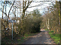
Byway across Warrington Common
This short section of byway (about 300 metres in length) links King's Lane with Northwich Road to the south of Rudheath Woods.
Image: © michael ely
Taken: 31 Mar 2007
0.24 miles
5
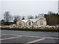
Former hire depot on the A50 at Rudheath Woods
Image: © Alexander P Kapp
Taken: 27 Dec 2010
0.25 miles