IMAGES TAKEN NEAR TO
Goostrey Lane, CREWE, CW4 8HE
Introduction
This page details the photographs taken nearby to Goostrey Lane, CW4 8HE by members of the Geograph project.
The Geograph project started in 2005 with the aim of publishing, organising and preserving representative images for every square kilometre of Great Britain, Ireland and the Isle of Man.

There are currently over 7.5m images from over14,400 individuals and you can help contribute to the project by visiting https://www.geograph.org.uk
Image Map
Images are licensed for reuse under creativecommons.org/licenses/by-sa/2.0
Notes
- Clicking on the map will re-center to the selected point.
- The higher the marker number, the further away the image location is from the centre of the postcode.
Image Listing (12 Images Found)
Images are licensed for reuse under creativecommons.org/licenses/by-sa/2.0
Image
Details
Distance
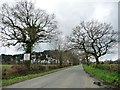
2
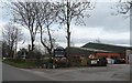
Goostrey Farm
Goostrey Farm has diversified as a centre with children's play equipment and refreshments on sale.
Image: © R Greenhalgh
Taken: 24 Mar 2007
0.04 miles

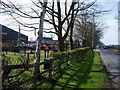
4
Ditch on the south side of Goostrey Lane
The placard reads 'Save prime Cheshire farm & horticultural land / let them eat sand". It refers to Sibelco UK Ltd's planning application to quarry sand at Rudheath Lodge Farm, on the north side of the land.
Image: © Christine Johnstone
Taken: 30 Mar 2017
0.07 miles
5
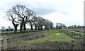
Trees on a field boundary, west of Goostrey Farm
South of Goostrey Lane.
Image: © Christine Johnstone
Taken: 30 Mar 2017
0.08 miles
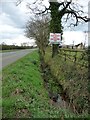
6
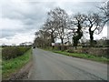
Goostrey Lane heading east to Goostrey Farm
The placard is a protest against a proposed sand quarry at Rudheath Lodge Farm.
Image: © Christine Johnstone
Taken: 30 Mar 2017
0.08 miles
7
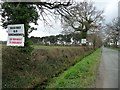
Placards on the south side of Goostrey Lane
Protesting about Sibelco UK Ltd's planning application for sand quarrying at Rudheath Lodge Farm, on the north side of the road.
Image: © Christine Johnstone
Taken: 30 Mar 2017
0.09 miles
8
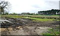
Horticultural land, west of Goostrey Farm
On the south side of Goostrey Lane.
Image: © Christine Johnstone
Taken: 30 Mar 2017
0.09 miles
9
![Farmland, Rudheath Lodge Farm [1]](https://s3.geograph.org.uk/geophotos/05/33/18/5331887_3276de75_120x120.jpg)
Farmland, Rudheath Lodge Farm [1]
On the north side of Goostrey Lane. Sibelco UK Ltd have applied for planning permission for extensive sand quarrying here.
Image: © Christine Johnstone
Taken: 30 Mar 2017
0.09 miles
10
'The Cheshire oak trees say ... no to sand quarry"
Goostrey Lane heading west to the A50. The placard refers to Sibelco UK Ltd's planning application for sand quarrying at Rudheath Lodge Farm.
Image: © Christine Johnstone
Taken: 30 Mar 2017
0.13 miles