IMAGES TAKEN NEAR TO
London Road, CREWE, CW4 8AX
Introduction
This page details the photographs taken nearby to London Road, CW4 8AX by members of the Geograph project.
The Geograph project started in 2005 with the aim of publishing, organising and preserving representative images for every square kilometre of Great Britain, Ireland and the Isle of Man.

There are currently over 7.5m images from over14,400 individuals and you can help contribute to the project by visiting https://www.geograph.org.uk
Image Map (Loading...)


Getting Data...Please wait
Leaflet Map data © OpenStreetMap
Images are licensed for reuse under creativecommons.org/licenses/by-sa/2.0
Notes
- Clicking on the map will re-center to the selected point.
- The higher the marker number, the further away the image location is from the centre of the postcode.
Image Listing (5 Images Found)
Images are licensed for reuse under creativecommons.org/licenses/by-sa/2.0
Image
Details
Distance
1
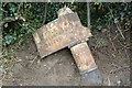
Old Milepost by the A50, London Road, Holmes Chapel
Cast iron post by the A50, in parish of Brereton (Congleton District), London Road, by the road. Old acorn open book, erected by the Lawton & Cranage turnpike trust in the 19th century. Right hand side broken.
Inscription reads:-
: BRERETON 1 / CHURCH LAWTON / 7½ MILES / NEWCASTLE 14 : : (Holmes Chapel / Knutsford / Warrington / Liverpool) :
Maker:-
: W H SMITH & CO / MAKERS / WHITCHURCH :
Grade II listed.
List Entry Number: 1330023 https://historicengland.org.uk/listing/the-list/list-entry/1330023
Milestone Society National ID: CH_NCWA14
Image: © JV Nicholls
Taken: 29 Sep 2008
0.14 miles
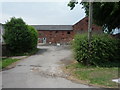
5
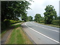
Bend in Dog Lane (A50) near Allum Brook Farm
Heading north west.
Image: © JThomas
Taken: 11 Jun 2016
0.24 miles