IMAGES TAKEN NEAR TO
Main Road, CREWE, CW3 9BZ
Introduction
This page details the photographs taken nearby to Main Road, CW3 9BZ by members of the Geograph project.
The Geograph project started in 2005 with the aim of publishing, organising and preserving representative images for every square kilometre of Great Britain, Ireland and the Isle of Man.

There are currently over 7.5m images from over14,400 individuals and you can help contribute to the project by visiting https://www.geograph.org.uk
Image Map
Images are licensed for reuse under creativecommons.org/licenses/by-sa/2.0
Notes
- Clicking on the map will re-center to the selected point.
- The higher the marker number, the further away the image location is from the centre of the postcode.
Image Listing (13 Images Found)
Images are licensed for reuse under creativecommons.org/licenses/by-sa/2.0
Image
Details
Distance
2
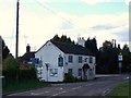
The Blue Bell, Wrinehill
Closed at the time of visit
Image: © Geoff Pick
Taken: 25 Apr 2009
0.06 miles
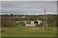
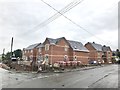
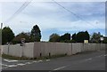
4
Building site in Wrinehill
This is the site of the former Blue Bell pub. More than seven years after its closure the pub sign, now bleached white, can still be seen in the extreme right of the photo.
For earlier views see http://www.geograph.org.uk/photo/4209571 (2014) and http://www.geograph.org.uk/photo/1271239 (2009)
For a later view with the houses nearly finished see http://www.geograph.org.uk/photo/5451670
Image: © Jonathan Hutchins
Taken: 19 Oct 2016
0.10 miles
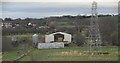
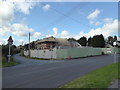
5
New houses in Wrinehill
These houses have been built on the site of a former pub, the Blue Bell. Earlier photos:
April 2009 http://www.geograph.org.uk/photo/1271239
October 2014 http://www.geograph.org.uk/photo/4209571
October 2016 http://www.geograph.org.uk/photo/5162341
Image: © Jonathan Hutchins
Taken: 28 Jun 2017
0.10 miles
6
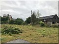
Site of the former Blue Bell pub, Wrinehill
The pub lay empty for over five years after its owner's death. It was demolished in 2013 and the site will be redeveloped for housing. Compare Image taken five years earlier in 2009. The old pub sign, bleached beyond recognition, can still be seen on the extreme right of the photo.
Update: housing under construction in October 2016 http://www.geograph.org.uk/photo/5162341
Image: © Jonathan Hutchins
Taken: 18 Oct 2014
0.11 miles
7
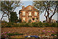
Converted Church
A very nicely converted chapel at Wrinehill, Staffordshire.
Image: © Peter Styles
Taken: 26 Apr 2007
0.12 miles