IMAGES TAKEN NEAR TO
Moorsfield Avenue, CREWE, CW3 0LA
Introduction
This page details the photographs taken nearby to Moorsfield Avenue, CW3 0LA by members of the Geograph project.
The Geograph project started in 2005 with the aim of publishing, organising and preserving representative images for every square kilometre of Great Britain, Ireland and the Isle of Man.

There are currently over 7.5m images from over14,400 individuals and you can help contribute to the project by visiting https://www.geograph.org.uk
Image Map
Images are licensed for reuse under creativecommons.org/licenses/by-sa/2.0
Notes
- Clicking on the map will re-center to the selected point.
- The higher the marker number, the further away the image location is from the centre of the postcode.
Image Listing (160 Images Found)
Images are licensed for reuse under creativecommons.org/licenses/by-sa/2.0
Image
Details
Distance
1
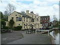
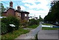
Shroppie Fly
Old canal warehouse converted to Public house at Audlem.
Image: © Andy and Hilary
Taken: 16 Apr 2005
0.02 miles
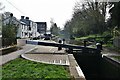
2
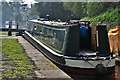
Audlem: In lock 14 on the Shropshire Union Canal
Image: © Michael Garlick
Taken: 28 Apr 2019
0.02 miles
3
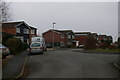
Tollgate Drive, Audlem
Built in 1969-70, the houses on Tollgate Drive form part of the first major housing estate to be built in Audlem. For some years after construction it was known as the Yew Tree Estate and letters addressed simply to "Plot [x], Yew Tree Estate". (This was its official name: as a large sign carrying the name of the builders, Cape, stood at the entrance it was known in the village for some years as the Cape Estate.) Once the roads on it were named and street addresses assigned, it comprised the central spine Tollgate Drive and the two short arms of Armstrong Close and Gemmull Close. Oak Tree Gate, which joins Tollgate Drive from the west at the lamp-post, is a much later addition.
Seen here are the ways that, in the decades since they were built, the basic house designs have been modified with extensions, pitched roofs to the garages, solar panels, etc. The majority of the houses seen here are the tile-fronted Fredricton type, which came in pairs with conjoined garages; other types of houses on the estate were called Calgary (the largest type, of which one can be seen above the van) and Guelph (not seen in this shot).
In the late 1960s it was clearly not envisaged that it would become the norm for households here to have two cars and many drives have been widened to make room for extra off-street parking.
Image: © Christopher Hilton
Taken: 15 Feb 2015
0.14 miles
4
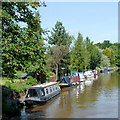
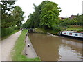
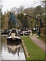
Private canal moorings at Audlem, Cheshire
Seen below Lock No 13 of the flight of fifteen. There are plenty of visitor moorings available on the towpath side of the canal in Audlem, but it can be a crowded and popular place in the summer.
The Shropshire Union Canal was opened in 1835 and is 66.5 miles long. The engineer was Thomas Telford.
Image: © Roger D Kidd
Taken: 24 May 2009
0.15 miles
5
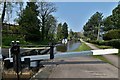
House next to Audlem Flight Lock No 13
Audlem Lock Flight consists of 15 locks, which drop 93 feet over one and a half miles of the Shropshire Union Canal.
Image: © Mat Fascione
Taken: 5 Jul 2019
0.15 miles
7
Audlem: Lock 13 on the Shropshire Union Canal
Image: © Michael Garlick
Taken: 28 Apr 2019
0.15 miles
8
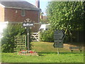
Audlem: village sign at the junction of Shropshire Street (A525) and Green Lane (A529)
The road signs in this photograph replace a much larger direction board that originally stood on the left of the photograph, to the left of the village sign. The stand of honeysuckle on the left was planted to cover the back of this direction board and left in place, twining around the legs of the signpost, when the board was removed.
Image: © Christopher Hilton
Taken: 28 Aug 2005
0.15 miles
9
Audlem: Lock 13 on the Shropshire Union Canal
Image: © Michael Garlick
Taken: 28 Apr 2019
0.16 miles
10
Warm as toast
The stove is smoking away nicely on this narrowboat as it lies moored along the canalside near the Shroppie Fly http://www.shroppiefly.co.uk/.
Image: © Ian Paterson
Taken: 27 Feb 2012
0.16 miles