IMAGES TAKEN NEAR TO
Moblake, CREWE, CW3 0HU
Introduction
This page details the photographs taken nearby to Moblake, CW3 0HU by members of the Geograph project.
The Geograph project started in 2005 with the aim of publishing, organising and preserving representative images for every square kilometre of Great Britain, Ireland and the Isle of Man.

There are currently over 7.5m images from over14,400 individuals and you can help contribute to the project by visiting https://www.geograph.org.uk
Image Map
Images are licensed for reuse under creativecommons.org/licenses/by-sa/2.0
Notes
- Clicking on the map will re-center to the selected point.
- The higher the marker number, the further away the image location is from the centre of the postcode.
Image Listing (3 Images Found)
Images are licensed for reuse under creativecommons.org/licenses/by-sa/2.0
Image
Details
Distance
1
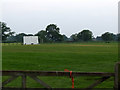
Audlem Cricket Club ground
View of the Audlem Cricket Club ground as seen from the entrance gate
Image: © Nigel Williams
Taken: 5 Jun 2006
0.05 miles
2
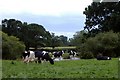
Gorsecroft Farm, Audlem
Cows grazing in pasture beside pond at Gorsecroft Farm - not far from Audlem cricket club's ground (see other image for this square).
Image: © Mike Harris
Taken: 21 Jun 2006
0.19 miles