IMAGES TAKEN NEAR TO
Kinsey Heath, CREWE, CW3 0DR
Introduction
This page details the photographs taken nearby to Kinsey Heath, CW3 0DR by members of the Geograph project.
The Geograph project started in 2005 with the aim of publishing, organising and preserving representative images for every square kilometre of Great Britain, Ireland and the Isle of Man.

There are currently over 7.5m images from over14,400 individuals and you can help contribute to the project by visiting https://www.geograph.org.uk
Image Map
Images are licensed for reuse under creativecommons.org/licenses/by-sa/2.0
Notes
- Clicking on the map will re-center to the selected point.
- The higher the marker number, the further away the image location is from the centre of the postcode.
Image Listing (5 Images Found)
Images are licensed for reuse under creativecommons.org/licenses/by-sa/2.0
Image
Details
Distance
1

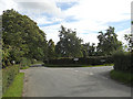
Old Direction Sign - Signpost by Kettle Lane, Kinsey Heath, Audlem parish
Annulus finial - 2 arms; Cheshire CC halo by the UC road, in parish of Audlem (Crewe and Nantwich District), Kettle Lane junction with Bagley Lane, Kinsey Heath.
Next to letter box.
Surveyed
Milestone Society National ID: CH_SJ6642
Image: © Milestone Society
Taken: Unknown
0.03 miles
3
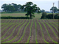
Field at Kinsey Heath
Crops growing in straight lines in a field at Kinsey Heath
Image: © Nigel Williams
Taken: 5 Jun 2006
0.17 miles
4
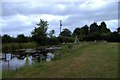
Pond restored as a nature reserve
Small ponds in this field at Kinsey Heath, Audlem, have been restored to make a small informal nature reserve. The tripod supports the "weatherstone", which gives an accurate weather forecast ... if wet = raining, if covered in white powder = snowing, etc.
Image: © Mike Harris
Taken: 21 Jun 2006
0.17 miles
5
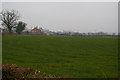
Kinseyheath Farm across the fields
Image: © Christopher Hilton
Taken: 15 Feb 2015
0.22 miles