IMAGES TAKEN NEAR TO
Field Lane, CREWE, CW2 8UU
Introduction
This page details the photographs taken nearby to Field Lane, CW2 8UU by members of the Geograph project.
The Geograph project started in 2005 with the aim of publishing, organising and preserving representative images for every square kilometre of Great Britain, Ireland and the Isle of Man.

There are currently over 7.5m images from over14,400 individuals and you can help contribute to the project by visiting https://www.geograph.org.uk
Image Map
Images are licensed for reuse under creativecommons.org/licenses/by-sa/2.0
Notes
- Clicking on the map will re-center to the selected point.
- The higher the marker number, the further away the image location is from the centre of the postcode.
Image Listing (20 Images Found)
Images are licensed for reuse under creativecommons.org/licenses/by-sa/2.0
Image
Details
Distance
2
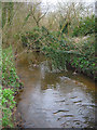
Wistaston Brook
A placid brook just south of Wistaston Green. This view from by Image shows the brook entering the small area of deciduous woodland shown in Image
Image: © Espresso Addict
Taken: 13 Mar 2007
0.04 miles
3
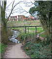
Footbridge over Wistaston Brook
Small footbridge over Wistaston Brook on the edge of a small area of woodland (see Image) just south of Wistaston Green. The footpath is one of a network of paved and unpaved footpaths in this recreational area. A sewage works is located to the south east, and a sewage pipe is visible in the distance
Image: © Espresso Addict
Taken: 13 Mar 2007
0.04 miles
4
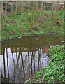
Small mere in woodland by Wistaston Green
A tranquil small pool in Image reflects the adjacent modern housing estate, part of Wistaston Green. The ground is carpeted with pungent wild garlic (Allium ursinum), which is very common in this area
Image: © Espresso Addict
Taken: 13 Mar 2007
0.05 miles
5
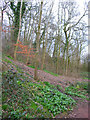
Woodland near Wistaston Brook
A small area of loose, mixed deciduous woodland surrounds Wistaston Brook south of Wistaston Green. The wood is crossed by several paths, and despite the adjacent housing estate (just visible through the trees), it forms a peaceful recreation area. The ground is carpeted with pungent wild garlic (Allium ursinum), which is very common in this area
Image: © Espresso Addict
Taken: 13 Mar 2007
0.05 miles
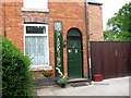
7
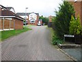
Waiting for God
Sheltered Accommodation in Wistaston provided by Wulvern Housing. 10 minute bus ride to Crewe town centre; 5 minute walk to the countryside; visits from badgers feeding in the back garden. Amazing.
Image: © Terry Hughes
Taken: 24 Sep 2009
0.06 miles
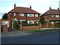
8
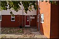
Whitegates, House, Wistaston Green
Sheltered housing.
Image: © JThomas
Taken: 5 Nov 2016
0.11 miles
10

Wistaston Brook
View just east of the bridges outside Wistaston Green, by the carpark for the network of public footpaths in this area
Image: © Espresso Addict
Taken: 13 Mar 2007
0.14 miles