IMAGES TAKEN NEAR TO
Wistaston Green Road, CREWE, CW2 8QJ
Introduction
This page details the photographs taken nearby to Wistaston Green Road, CW2 8QJ by members of the Geograph project.
The Geograph project started in 2005 with the aim of publishing, organising and preserving representative images for every square kilometre of Great Britain, Ireland and the Isle of Man.

There are currently over 7.5m images from over14,400 individuals and you can help contribute to the project by visiting https://www.geograph.org.uk
Image Map
Images are licensed for reuse under creativecommons.org/licenses/by-sa/2.0
Notes
- Clicking on the map will re-center to the selected point.
- The higher the marker number, the further away the image location is from the centre of the postcode.
Image Listing (10 Images Found)
Images are licensed for reuse under creativecommons.org/licenses/by-sa/2.0
Image
Details
Distance
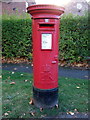
2
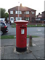
Elizabeth II postbox on Readesdale Avenue
Outside the Post Office.
Postbox No. CW2 153.
Image: © JThomas
Taken: 5 Nov 2016
0.15 miles
3
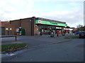
Co-operative food store and Post office, Readesdale Avenue
Showing position of Postbox No. CW2 153.
Image: © JThomas
Taken: 5 Nov 2016
0.15 miles
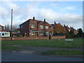
5
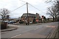
The Woodside public house
View SSE from Valley Road.
Image: © David P Howard
Taken: 25 Feb 2011
0.16 miles
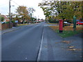
6
Elizabeth II postbox on Wistaston Green Road
Postbox No. CW2 119.
Image: © JThomas
Taken: 5 Nov 2016
0.17 miles
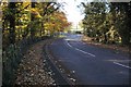
7
Wistaston Green Road
Showing position of Postbox No. CW2 119.
Image: © JThomas
Taken: 5 Nov 2016
0.17 miles
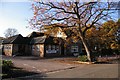
8
Valley Road, Wistaston
Known locally as "Joey the Swan"
Image: © Mike Grose
Taken: 18 Nov 2006
0.18 miles
9
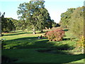
Joey the Swan recreation area
Next to Wistaston Brook
Image: © Margaret Sutton
Taken: 25 Oct 2010
0.21 miles