IMAGES TAKEN NEAR TO
Tabley Road, CREWE, CW2 8PW
Introduction
This page details the photographs taken nearby to Tabley Road, CW2 8PW by members of the Geograph project.
The Geograph project started in 2005 with the aim of publishing, organising and preserving representative images for every square kilometre of Great Britain, Ireland and the Isle of Man.

There are currently over 7.5m images from over14,400 individuals and you can help contribute to the project by visiting https://www.geograph.org.uk
Image Map
Images are licensed for reuse under creativecommons.org/licenses/by-sa/2.0
Notes
- Clicking on the map will re-center to the selected point.
- The higher the marker number, the further away the image location is from the centre of the postcode.
Image Listing (9 Images Found)
Images are licensed for reuse under creativecommons.org/licenses/by-sa/2.0
Image
Details
Distance
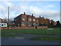
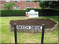
4
Whitegates, House, Wistaston Green
Sheltered housing.
Image: © JThomas
Taken: 5 Nov 2016
0.13 miles
5
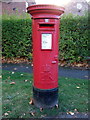
Elizabeth II postbox on Wistaston Green Road
Postbox No. CW2 119.
Image: © JThomas
Taken: 5 Nov 2016
0.19 miles
6
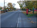
Wistaston Green Road
Showing position of Postbox No. CW2 119.
Image: © JThomas
Taken: 5 Nov 2016
0.19 miles
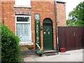
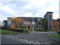
7
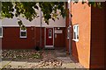
Waiting for God
Sheltered Accommodation in Wistaston provided by Wulvern Housing. 10 minute bus ride to Crewe town centre; 5 minute walk to the countryside; visits from badgers feeding in the back garden. Amazing.
Image: © Terry Hughes
Taken: 24 Sep 2009
0.20 miles