IMAGES TAKEN NEAR TO
Aldersey Road, CREWE, CW2 8NR
Introduction
This page details the photographs taken nearby to Aldersey Road, CW2 8NR by members of the Geograph project.
The Geograph project started in 2005 with the aim of publishing, organising and preserving representative images for every square kilometre of Great Britain, Ireland and the Isle of Man.

There are currently over 7.5m images from over14,400 individuals and you can help contribute to the project by visiting https://www.geograph.org.uk
Image Map
Images are licensed for reuse under creativecommons.org/licenses/by-sa/2.0
Notes
- Clicking on the map will re-center to the selected point.
- The higher the marker number, the further away the image location is from the centre of the postcode.
Image Listing (8 Images Found)
Images are licensed for reuse under creativecommons.org/licenses/by-sa/2.0
Image
Details
Distance
1

Capenhurst Avenue, Crewe
Taken on a sunny but chilly October afternoon.
Image: © Margaret Sutton
Taken: 25 Oct 2010
0.12 miles
2
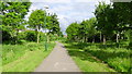
Public Footpath
Photograph taken from Doddington road showing the footpath known locally as both "The Black path" and "The Ravine"
Image: © Garry Lavender-Rimmer
Taken: 28 May 2015
0.12 miles
3
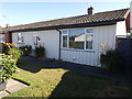
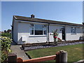
Prefabricated Bungalow
This is one "prefab" of only 2 or 3 on an estate of approx 70 bungalows that are almost original in appearance.
This property is privately owned.
These prefabs were built to house servicemen returning home from World War 2 and had a life expectancy of 15 to 20 years but are now over 60 years old.
Image: © Garry Lavender-Rimmer
Taken: 5 Aug 2018
0.16 miles
4
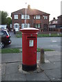
Elizabeth II postbox on Readesdale Avenue
Outside the Post Office.
Postbox No. CW2 153.
Image: © JThomas
Taken: 5 Nov 2016
0.16 miles
5
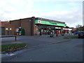
Co-operative food store and Post office, Readesdale Avenue
Showing position of Postbox No. CW2 153.
Image: © JThomas
Taken: 5 Nov 2016
0.16 miles
6
Prefabricated Bungalow
This bungalow shows how the majority of this estate looks now having been clad with insulation though some have been coated in brick.
Image: © Garry Lavender-Rimmer
Taken: 5 Aug 2018
0.17 miles
7

Public Footpath
Photograph taken from Alton street showing the footpath known locally as both "The Black Path" or "The Ravine"
Image: © Garry Lavender-Rimmer
Taken: 26 May 2015
0.18 miles
8
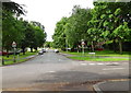
Moreton Road
Moreton Road from South entrance of Queens Park.
Image: © Garry Lavender-Rimmer
Taken: 12 Jul 2015
0.20 miles