IMAGES TAKEN NEAR TO
Edinburgh Road, CREWE, CW2 8JH
Introduction
This page details the photographs taken nearby to Edinburgh Road, CW2 8JH by members of the Geograph project.
The Geograph project started in 2005 with the aim of publishing, organising and preserving representative images for every square kilometre of Great Britain, Ireland and the Isle of Man.

There are currently over 7.5m images from over14,400 individuals and you can help contribute to the project by visiting https://www.geograph.org.uk
Image Map
Images are licensed for reuse under creativecommons.org/licenses/by-sa/2.0
Notes
- Clicking on the map will re-center to the selected point.
- The higher the marker number, the further away the image location is from the centre of the postcode.
Image Listing (12 Images Found)
Images are licensed for reuse under creativecommons.org/licenses/by-sa/2.0
Image
Details
Distance
1
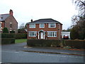
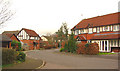
Sandringham Drive, Wistaston
Orange-brick detached 1950s/60s houses, typical of the quiet late-20th-century housing estate that extends between Church Lane and Crewe Road in the village of Wistaston
Image: © Espresso Addict
Taken: 1 Mar 2007
0.08 miles
4
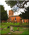
St Mary's Church, Wistaston
Red-brick parish church of Wistaston. The main grade-II-listed building by George Latham dates from 1827, with later additions. View from the churchyard on the southern side. For further information, see: http://www.imagesofengland.org.uk/search/details.aspx?id=57015
Image: © Espresso Addict
Taken: 1 Mar 2007
0.10 miles
5
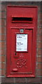
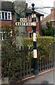
George VI postbox on Crewe Road, Wistaston
Postbox No. CW2 58.
See Image] for context.
Image: © JThomas
Taken: 3 Dec 2016
0.16 miles
6
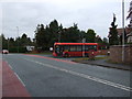
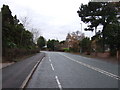
Crewe Road, Wistaston
Junction with Church Lane.
Showing position of Postbox No. CW2 58.
See Image] for postbox.
Image: © JThomas
Taken: 3 Dec 2016
0.16 miles
7
Marys Gate, Wistaston
Part of a small 21st-century housing estate lying to the west of Church Lane, just north of St Mary's Church, on the western edge of the village of Wistaston. The black-and-white timber gables imitate the many half-timbered cottages locally, while the circular windows are reminiscent of the local red-brick barns
Image: © Espresso Addict
Taken: 1 Mar 2007
0.18 miles
8
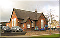
Wistaston Junior School
Small red-brick junior school, dating from 1872, on Church Lane towards the north of the village of Wistaston, adjacent to the modern Image The building is similar to many other village schools in this area, such as the nearby Image
Image: © Espresso Addict
Taken: 1 Mar 2007
0.21 miles
9
Old Direction Sign - Signpost by the A534, Crewe Road, Wistaston
Pawn finial - 1 arm; Cheshire CCC octagonal by the A534, in parish of Wistaston (Crewe and Nantwich District), No 397 Crewe Road, opposite junction with Wistaston Road.
Loss report from M Bardell.
Lost? Top of truncated column still visible buried in hedge, Streetview May 2018.
Cheshire HER listed.
SMR Number: 5486 https://www.heritagegateway.org.uk/Gateway/Results_Single.aspx?uid=MCH16449&resourceID=1004
Milestone Society National ID: CH_SJ6853
Image: © Milestone Society
Taken: Unknown
0.24 miles
10
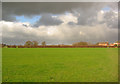
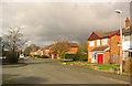
Storm clouds west of Wistaston
Flat pasture to the west of Wistaston, with mature trees in the field boundaries. The housing estate (right) is part of the Marys Gate estate which straddles this gridsquare and Image (see Image). View north east from the path between Wistaston School and Colleys Lane, near Church House Farm
Image: © Espresso Addict
Taken: 1 Mar 2007
0.24 miles