IMAGES TAKEN NEAR TO
Shelley Drive, CREWE, CW2 8DJ
Introduction
This page details the photographs taken nearby to Shelley Drive, CW2 8DJ by members of the Geograph project.
The Geograph project started in 2005 with the aim of publishing, organising and preserving representative images for every square kilometre of Great Britain, Ireland and the Isle of Man.

There are currently over 7.5m images from over14,400 individuals and you can help contribute to the project by visiting https://www.geograph.org.uk
Image Map
Images are licensed for reuse under creativecommons.org/licenses/by-sa/2.0
Notes
- Clicking on the map will re-center to the selected point.
- The higher the marker number, the further away the image location is from the centre of the postcode.
Image Listing (12 Images Found)
Images are licensed for reuse under creativecommons.org/licenses/by-sa/2.0
Image
Details
Distance
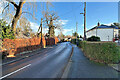
2
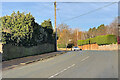
Broughton Lane junction
Tree at the corner of Broughton Lane and Wistaston Green Road
Image: © Margaret Sutton
Taken: 25 Oct 2010
0.17 miles
3
Joey's Island
This is the view from the "Joey the Swan" commemorative planter and sign at the junction of Church Lane, Broughton Lane and Wistaston Green Road.
Image: © Terry Hughes
Taken: 21 Mar 2010
0.20 miles
4
Time Capsule Plaque
Does what it says on the tin.
Image: © Terry Hughes
Taken: 21 Mar 2010
0.20 miles
5
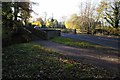
Wistaston Brook Bridge at "Joey the Swan"
A newer wooden footbridge has been added alongside the old brick bridge - the road is quite narrow at this point. Known as Gresty Brook further upstream, this brook joins the river Weaver near Rookery Hall
Image: © Mike Grose
Taken: 18 Nov 2006
0.20 miles
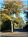
6
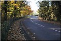
Valley Road, Wistaston
Known locally as "Joey the Swan"
Image: © Mike Grose
Taken: 18 Nov 2006
0.24 miles
7
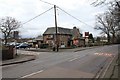
The Woodside public house
View SSE from Valley Road.
Image: © David P Howard
Taken: 25 Feb 2011
0.24 miles
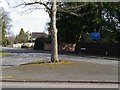
9
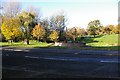
"Joey the Swan"
This area is known locally as "Joey the Swan" and has been landscaped with a linear park in the distance. A pond - just beyond the sign has been drained and brook cleaned up with a play area to right of shot, all part of a Millennium Project. The large rock has a time capsule beneath it.
Image: © Mike Grose
Taken: 18 Nov 2006
0.25 miles
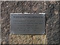
10
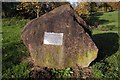
Millennium Rock at "Joey the Swan"
The plaque affixed to the rock states: Wistaston Millennium - for future generations, buried below is a capsule containing information about life in the village at the start of the Millennium. Also the History of Wistaston from Domesday to the year 2000.
Image: © Mike Grose
Taken: 18 Nov 2006
0.25 miles