IMAGES TAKEN NEAR TO
Rosehill Road, CREWE, CW2 8AX
Introduction
This page details the photographs taken nearby to Rosehill Road, CW2 8AX by members of the Geograph project.
The Geograph project started in 2005 with the aim of publishing, organising and preserving representative images for every square kilometre of Great Britain, Ireland and the Isle of Man.

There are currently over 7.5m images from over14,400 individuals and you can help contribute to the project by visiting https://www.geograph.org.uk
Image Map
Images are licensed for reuse under creativecommons.org/licenses/by-sa/2.0
Notes
- Clicking on the map will re-center to the selected point.
- The higher the marker number, the further away the image location is from the centre of the postcode.
Image Listing (18 Images Found)
Images are licensed for reuse under creativecommons.org/licenses/by-sa/2.0
Image
Details
Distance
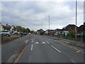
1
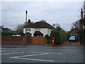
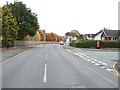
House on Nantwich Road, Crewe
Showing position of Postbox No. CW2 128.
See Image] for postbox.
Image: © JThomas
Taken: 3 Dec 2016
0.07 miles
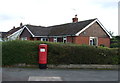
2
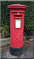
Elizabeth II postbox on Nantwich Road, Crewe
Postbox No. CW2 128.
See Image] for context.
Image: © JThomas
Taken: 3 Dec 2016
0.08 miles
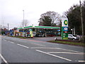
6
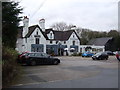
Ye Olde Manor public house, Crewe
On Nantwich Road.
Image: © JThomas
Taken: 3 Dec 2016
0.13 miles
7
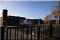
Vine Tree Primary School, Dane Bank Avenue
Image: © Mike Grose
Taken: 18 Nov 2006
0.15 miles
9
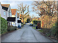
Dane Bank Avenue, Crewe
Showing position of Postbox No. CW2 294.
Image: © JThomas
Taken: 5 Nov 2016
0.16 miles
10
Elizabeth II postbox on Dane Bank Avenue, Crewe
Postbox No. CW2 294.
Image: © JThomas
Taken: 5 Nov 2016
0.16 miles