IMAGES TAKEN NEAR TO
Lewis Street, CREWE, CW2 7QR
Introduction
This page details the photographs taken nearby to Lewis Street, CW2 7QR by members of the Geograph project.
The Geograph project started in 2005 with the aim of publishing, organising and preserving representative images for every square kilometre of Great Britain, Ireland and the Isle of Man.

There are currently over 7.5m images from over14,400 individuals and you can help contribute to the project by visiting https://www.geograph.org.uk
Image Map
Images are licensed for reuse under creativecommons.org/licenses/by-sa/2.0
Notes
- Clicking on the map will re-center to the selected point.
- The higher the marker number, the further away the image location is from the centre of the postcode.
Image Listing (94 Images Found)
Images are licensed for reuse under creativecommons.org/licenses/by-sa/2.0
Image
Details
Distance
1
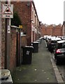
Home Watch Area notice and Designated Public Place notice, Lewis Street, Crewe
The sign on a lamppost faces the Flag Lane junction. Below the sign, a sticker shows that this is a Designated Public Place. If you continue to drink alcohol in this area when asked not to do so by a police officer, you are liable to a fine on conviction. You may be arrested if you fail to surrender any intoxicating liquor to a police officer.
Image: © Jaggery
Taken: 15 Feb 2017
0.02 miles
2
Up Flag Lane, Crewe
Flag Lane ascends northwards from Wistaston Road.
Image: © Jaggery
Taken: 15 Feb 2017
0.03 miles
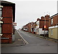
4
Lewis Street towards Bridle Road, Crewe
From the corner of Flag Lane.
Image: © Jaggery
Taken: 15 Feb 2017
0.03 miles
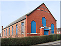
5
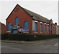
Boarded-up former Methodist church on a Crewe corner
On the corner of Flag Lane and Bridle Road, viewed in February 2017.
On the left, an inscription on the Flag Lane side shows INDEPENDENT METHODIST CHURCH 1909. http://www.geograph.org.uk/photo/5290411
Image: © Jaggery
Taken: 15 Feb 2017
0.04 miles
6
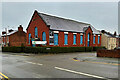
YSD Theatre School, Flag Lane
Housed in a somewhat dilapidated former independent methodist church building (dated 1909 Image])
Image: © David Dixon
Taken: 28 Dec 2024
0.04 miles
8
Corner of Wistaston Road and Flag Lane, Crewe
Flag Lane is on the right.
Image: © Jaggery
Taken: 15 Feb 2017
0.04 miles
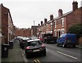
9
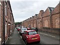
Bridge Road, Crewe
Terraced houses on Bridge Road facing the rear of former railway buildings of Crewe Electric Depot. The depot still exists though reduced in size and the buildings shown are no longer in railway use.
Image: © David Robinson
Taken: 5 Oct 2019
0.04 miles
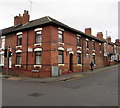
10
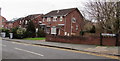
Bridle Road houses, Crewe
On the west side of Flag Lane.
Image: © Jaggery
Taken: 15 Feb 2017
0.04 miles