IMAGES TAKEN NEAR TO
Gainsborough Road, CREWE, CW2 7PL
Introduction
This page details the photographs taken nearby to Gainsborough Road, CW2 7PL by members of the Geograph project.
The Geograph project started in 2005 with the aim of publishing, organising and preserving representative images for every square kilometre of Great Britain, Ireland and the Isle of Man.

There are currently over 7.5m images from over14,400 individuals and you can help contribute to the project by visiting https://www.geograph.org.uk
Image Map
Images are licensed for reuse under creativecommons.org/licenses/by-sa/2.0
Notes
- Clicking on the map will re-center to the selected point.
- The higher the marker number, the further away the image location is from the centre of the postcode.
Image Listing (7 Images Found)
Images are licensed for reuse under creativecommons.org/licenses/by-sa/2.0
Image
Details
Distance
3
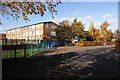
Kings Grove School, Buchan Grove
This school straddles the kilometre square boundary, the far right- just out of shot is in the next square north.
Image: © Mike Grose
Taken: 18 Nov 2006
0.21 miles
4
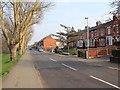
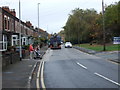
Alton Street
View ESE along Alton Street towards its junction with Clifton Avenue.
Image: © David P Howard
Taken: 22 Mar 2012
0.21 miles
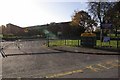
6
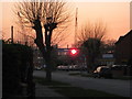
College construction site
Sun setting through the steel work construction of the new South Cheshire College building, taken from Carlisle St.
Image: © Tom McCallister
Taken: 2 Apr 2009
0.24 miles