IMAGES TAKEN NEAR TO
Westminster Street, CREWE, CW2 7LG
Introduction
This page details the photographs taken nearby to Westminster Street, CW2 7LG by members of the Geograph project.
The Geograph project started in 2005 with the aim of publishing, organising and preserving representative images for every square kilometre of Great Britain, Ireland and the Isle of Man.

There are currently over 7.5m images from over14,400 individuals and you can help contribute to the project by visiting https://www.geograph.org.uk
Image Map
Images are licensed for reuse under creativecommons.org/licenses/by-sa/2.0
Notes
- Clicking on the map will re-center to the selected point.
- The higher the marker number, the further away the image location is from the centre of the postcode.
Image Listing (120 Images Found)
Images are licensed for reuse under creativecommons.org/licenses/by-sa/2.0
Image
Details
Distance
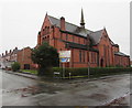
2
Crewe - former church on Stalbridge Road
Now occupied by "Funsters" - an indoor playground for children.
Image: © Dave Bevis
Taken: 4 Mar 2013
0.10 miles
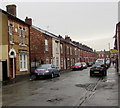
3
West along Derrington Avenue, Crewe
Viewed across Edleston Road.
Image: © Jaggery
Taken: 15 Feb 2017
0.10 miles
4
Funsters, Stalbridge Road, Crewe
Children's play & party centre in a former Baptist church on the corner of Stalbridge Road and Brooklyn Street.
Image: © Jaggery
Taken: 15 Feb 2017
0.10 miles
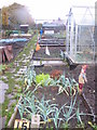
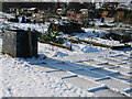
6
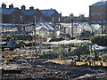
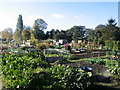
Shadows on a frosty morning
Ruskin allotment with part of Ruskin school in the background
Image: © tom
Taken: 7 Dec 2008
0.11 miles
7
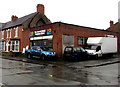
The Second Hand Furniture Store, Crewe
At 7 Stalbridge Road, on the corner of Brooklyn Street.
Image: © Jaggery
Taken: 15 Feb 2017
0.12 miles
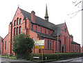
8
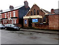
Hope Church Central in Crewe
Viewed across Derrington Avenue in February 2017. The former Welsh Congregational Chapel
is now the building which houses the weekly meetings of Hope Church Central.
Image: © Jaggery
Taken: 15 Feb 2017
0.12 miles
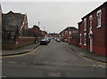
10
West along Maxwell Street, Crewe
From Edleston Road along Maxwell Street towards Derrington Avenue.
Image: © Jaggery
Taken: 15 Feb 2017
0.13 miles