IMAGES TAKEN NEAR TO
Maxwell Street, CREWE, CW2 7JD
Introduction
This page details the photographs taken nearby to Maxwell Street, CW2 7JD by members of the Geograph project.
The Geograph project started in 2005 with the aim of publishing, organising and preserving representative images for every square kilometre of Great Britain, Ireland and the Isle of Man.

There are currently over 7.5m images from over14,400 individuals and you can help contribute to the project by visiting https://www.geograph.org.uk
Image Map
Images are licensed for reuse under creativecommons.org/licenses/by-sa/2.0
Notes
- Clicking on the map will re-center to the selected point.
- The higher the marker number, the further away the image location is from the centre of the postcode.
Image Listing (200 Images Found)
Images are licensed for reuse under creativecommons.org/licenses/by-sa/2.0
Image
Details
Distance
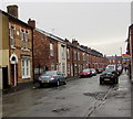
1
Maxwell Street, Crewe
Terraced housing west of Edleston Road.
Image: © Stephen McKay
Taken: 13 May 2008
0.01 miles
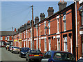
2
Maxwell Street, Crewe
Looking along the terrace on the north side of this street off Edleston Road.
Image: © Stephen McKay
Taken: 13 May 2008
0.02 miles
3
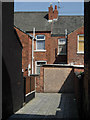
Maxwell Street, Crewe
In traditional terraced street style, this alley runs along the back of houses on Maxwell Street and parallel Lawton Street (opposite).
Image: © Stephen McKay
Taken: 13 May 2008
0.02 miles
4
Hope Church Central in Crewe
Viewed across Derrington Avenue in February 2017. The former Welsh Congregational Chapel
is now the building which houses the weekly meetings of Hope Church Central.
Image: © Jaggery
Taken: 15 Feb 2017
0.04 miles
5
West along Maxwell Street, Crewe
From Edleston Road along Maxwell Street towards Derrington Avenue.
Image: © Jaggery
Taken: 15 Feb 2017
0.04 miles
6
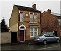
Detached house, Maxwell Street, Crewe
Viewed from the corner of Edleston Road. Faded in February 2017, a tablet
on the wall between first floor windows shows ST JOHN'S COTTAGE 1884.
Image: © Jaggery
Taken: 15 Feb 2017
0.04 miles
7
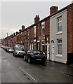
Row of houses and cars, Maxwell Street, Crewe
The north side of Maxwell Street viewed from near the corner of Edleston Road.
Image: © Jaggery
Taken: 15 Feb 2017
0.04 miles
8
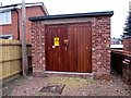
Derrington Avenue electricity substation, Crewe
The electricity substation is a brick structure with a wooden door,
viewed across a wooden fence on the north side of Derrington Avenue.
Image: © Jaggery
Taken: 15 Feb 2017
0.04 miles
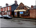
9
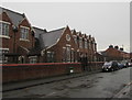
Former school buildings, Derrington Avenue, Crewe
The northern side of a former school. Its southern side is alongside Stalbridge Road.
Image: © Jaggery
Taken: 15 Feb 2017
0.05 miles
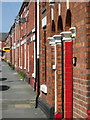
10
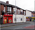
European Shop, Edleston Road, Crewe
Depictions of the flags of many nations are arranged vertically at both edges of the shop.
Text on the shop front is more specific - POLISH ROMANIAN & SLOVAKIAN FOOD.
Image: © Jaggery
Taken: 15 Feb 2017
0.05 miles