IMAGES TAKEN NEAR TO
Lord Street, CREWE, CW2 7DU
Introduction
This page details the photographs taken nearby to Lord Street, CW2 7DU by members of the Geograph project.
The Geograph project started in 2005 with the aim of publishing, organising and preserving representative images for every square kilometre of Great Britain, Ireland and the Isle of Man.

There are currently over 7.5m images from over14,400 individuals and you can help contribute to the project by visiting https://www.geograph.org.uk
Image Map
Images are licensed for reuse under creativecommons.org/licenses/by-sa/2.0
Notes
- Clicking on the map will re-center to the selected point.
- The higher the marker number, the further away the image location is from the centre of the postcode.
Image Listing (271 Images Found)
Images are licensed for reuse under creativecommons.org/licenses/by-sa/2.0
Image
Details
Distance
1
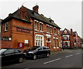
IRIS Vision Resource Centre, Crewe
Viewed across Chapel Street from the corner of Edleston Road. The IRIS website states that IRIS is a local charity governed by local visually impaired people which takes its name from the ambitions expressed by those who formed the organisation in the early 1990s – to achieve Independence and Rehabilitation for those with Impaired Sight.
It became a registered charity in March 1995. A few years later it acquired its own premise here in Chapel Street which it developed as a resource centre. From here a variety of services are run for (and often provided by) visually impaired people.
Image: © Jaggery
Taken: 15 Feb 2017
0.02 miles
2
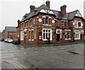
The Imperial in Crewe
The Imperial pub (formerly the Imperial Hotel) is at 183 Edleston Road on the corner of Chapel Street.
http://www.geograph.org.uk/photo/5284474 to the pub name sign on the right.
Image: © Jaggery
Taken: 15 Feb 2017
0.02 miles
3
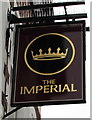
The Imperial pub name sign, Crewe
Hanging from a wall bracket on the right here. http://www.geograph.org.uk/photo/5284469
Image: © Jaggery
Taken: 15 Feb 2017
0.03 miles
4
North side of the Imperial, Crewe
The Chapel Street side of this pub http://www.geograph.org.uk/photo/5284469
Image: © Jaggery
Taken: 15 Feb 2017
0.03 miles
5
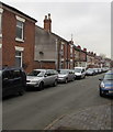
West side of Lord Street, Crewe
Houses on the west side of Lord Street viewed from the corner of Union Street.
Image: © Jaggery
Taken: 15 Feb 2017
0.03 miles
6
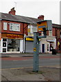
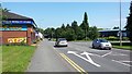
Edleston Road speed camera, Crewe
On the east side of the A5078 Edleston Road near the Chapel Street junction.
Image: © Jaggery
Taken: 15 Feb 2017
0.04 miles
7
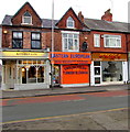
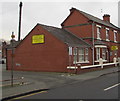
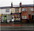
Eastern European Mini Market, Edleston Road, Crewe
Specialising in English, Polish, Turkish and Slovakian food.
Image: © Jaggery
Taken: 15 Feb 2017
0.04 miles
8
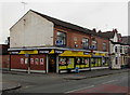
Bargain Busters on a Crewe corner
Bargain Busters is a Premier convenience store at 156-158 Edleston Road, on the corner of Maxwell Street.
Image: © Jaggery
Taken: 15 Feb 2017
0.04 miles
9
Mill Street
Looking north on Mill Street, Crewe.
Image: © Peter Mackenzie
Taken: 17 Jun 2017
0.04 miles
10
Istanbul in Crewe
Istanbul takeaway (kebabs, fried chicken, burgers, pizzas) is at 161 Edleston Road.
The tablet on the first floor shows BURDETT TERRACE and the year 1881.
Image: © Jaggery
Taken: 15 Feb 2017
0.04 miles