IMAGES TAKEN NEAR TO
Gorsty Hill Close, CREWE, CW2 5QS
Introduction
This page details the photographs taken nearby to Gorsty Hill Close, CW2 5QS by members of the Geograph project.
The Geograph project started in 2005 with the aim of publishing, organising and preserving representative images for every square kilometre of Great Britain, Ireland and the Isle of Man.

There are currently over 7.5m images from over14,400 individuals and you can help contribute to the project by visiting https://www.geograph.org.uk
Image Map
Images are licensed for reuse under creativecommons.org/licenses/by-sa/2.0
Notes
- Clicking on the map will re-center to the selected point.
- The higher the marker number, the further away the image location is from the centre of the postcode.
Image Listing (7 Images Found)
Images are licensed for reuse under creativecommons.org/licenses/by-sa/2.0
Image
Details
Distance
2
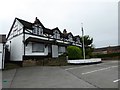
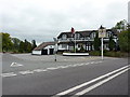
Balterley: Broughton Arms
The pub closed late in 2015 and is intended to be converted into a restaurant. The front of the building will be retained, but the rear section including some function rooms (shown here) will be demolished.
Image: © Jonathan Hutchins
Taken: 18 Jun 2016
0.08 miles
3
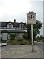
Balterley: Broughton Arms
The pub closed late in 2015 and is intended to be converted into a restaurant.
Image: © Jonathan Hutchins
Taken: 18 Jun 2016
0.09 miles
4
Balterley: Broughton Arms
The pub closed late in 2015 and is intended to be converted into a restaurant.
Image: © Jonathan Hutchins
Taken: 18 Jun 2016
0.09 miles
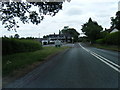
6
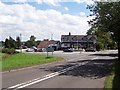
Gorstyhill
The pub, the Broughton Arms, has a Cheshire address and was in Cheshire until 1965, when the boundary was moved to make Gorstyhill and Balterley Heath into a single community. I was standing on the current boundary to take the photo. The road to the left, the B5500, used to be the A52.
Image: © Adrian Bailey
Taken: 2 Aug 2005
0.13 miles
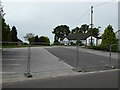
7
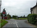
Cross roads, Balterley Heath
Junction of Englesea Brook Lane, Post Office Lane with the B5500
Image: © Alexander P Kapp
Taken: 13 Sep 2010
0.15 miles