IMAGES TAKEN NEAR TO
Greenfields Avenue, CREWE, CW2 5HE
Introduction
This page details the photographs taken nearby to Greenfields Avenue, CW2 5HE by members of the Geograph project.
The Geograph project started in 2005 with the aim of publishing, organising and preserving representative images for every square kilometre of Great Britain, Ireland and the Isle of Man.

There are currently over 7.5m images from over14,400 individuals and you can help contribute to the project by visiting https://www.geograph.org.uk
Image Map
Images are licensed for reuse under creativecommons.org/licenses/by-sa/2.0
Notes
- Clicking on the map will re-center to the selected point.
- The higher the marker number, the further away the image location is from the centre of the postcode.
Image Listing (9 Images Found)
Images are licensed for reuse under creativecommons.org/licenses/by-sa/2.0
Image
Details
Distance
1
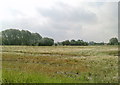
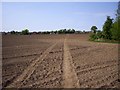
Farmland soon to be a building site
Farmland off the Newcastle Road, Shavington soon to be built on.
Another Greenfield site land lost to builders instead of using a Brownfield site.
Image: © Garry Lavender-Rimmer
Taken: 4 Jul 2015
0.13 miles
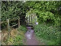
3
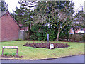
Commemorative planting
At the junction where Barons Road meets Main Road, there are two circular flower beds planted with roses. The small plaque in the bed is inscribed: 'These roses were planted by the people of Shavington to commemorate the Silver Jubilee of Queen Elizabeth II 7th June 1977'.
Image: © Richard Dorrell
Taken: 22 Jan 2011
0.19 miles
4
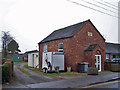
Former chapel in Main Street
The building has an engraved stone in its gable which reads: 'Christs Free Gospel Chapel 1871'. The building now appears to be in use as a public hall.
Image: © Richard Dorrell
Taken: 22 Jan 2011
0.21 miles
6
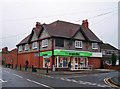
Shavington Co-op
Located in Main Street at its junction with Rope Lane.
Image: © Richard Dorrell
Taken: 22 Jan 2011
0.24 miles
7
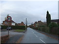
Main Road, Shavington
Looking east. The building just right of centre with the rendered upper storey is the Co-op store on the corner of Rope Lane.
Image: © Richard Dorrell
Taken: 22 Jan 2011
0.24 miles
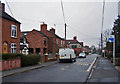
8
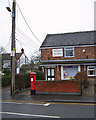
Shavington Post Office
Located in Main Street, and occupying on half of a residential semi-detached house.
Image: © Richard Dorrell
Taken: 22 Jan 2011
0.24 miles