IMAGES TAKEN NEAR TO
Field View Road, CONGLETON, CW12 4UG
Introduction
This page details the photographs taken nearby to Field View Road, CW12 4UG by members of the Geograph project.
The Geograph project started in 2005 with the aim of publishing, organising and preserving representative images for every square kilometre of Great Britain, Ireland and the Isle of Man.

There are currently over 7.5m images from over14,400 individuals and you can help contribute to the project by visiting https://www.geograph.org.uk
Image Map
Images are licensed for reuse under creativecommons.org/licenses/by-sa/2.0
Notes
- Clicking on the map will re-center to the selected point.
- The higher the marker number, the further away the image location is from the centre of the postcode.
Image Listing (10 Images Found)
Images are licensed for reuse under creativecommons.org/licenses/by-sa/2.0
Image
Details
Distance
1
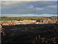
New housing development, Loachbrook Meadow, Congleton
Image: © Colin Park
Taken: 3 Nov 2014
0.03 miles
2
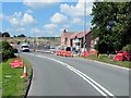
New Housing Development, Loachbrook Meadow
Image: © David Dixon
Taken: 17 Jul 2014
0.13 miles
4
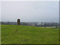
Trig point off Sandy Lane, Congleton
This trig point stands in the middle of a field just off Sandy Lane, Congleton. Congleton High School can be seen in the distance on the right.
Image: © Colin Park
Taken: 16 Jan 2006
0.18 miles
5

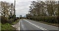
Trig Point in pasture
Looking east from Sandy Lane across Cheshire pasture land with the top of Congleton High School visible centre right, and The Cloud (343m) in the distance in SJ9063.
Image: © Jonathan Billinger
Taken: 16 Dec 2008
0.19 miles
8
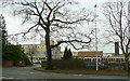
Congleton High School
Situated on the western outskirts of the town, on Box Lane, West Heath.
Image: © Jonathan Billinger
Taken: 16 Dec 2008
0.21 miles
9
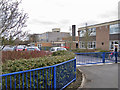
Congleton High School
Located in Box Lane. The school was established in September 2000 as an 11-18 comprehensive school for 1100 students. The school takes virtually all of the secondary aged students from seven local primary schools as well as other local primary students from North Staffordshire. In addition to the main school, a purpose-built Sixth Form Centre opened in November 2007 and accommodates up to 200 students. The school has Specialist Status for Engineering.
Image: © Richard Dorrell
Taken: 19 Mar 2012
0.22 miles
10
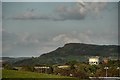
The Cloud , Bosley
View of The Cloud from Sandy Lane.
The Cloud is a distinctive hill just outside of the boundaries of the Peak District National Park. It is visible from a great distance across the Cheshire Plain.
At 343 metres (1,125 ft) in height, it is one of the tallest hills in the area. The Cloud lies just off the A523 road near the village of Bosley in South Cheshire, and offers excellent views over Congleton, Macclesfield and the Greater Manchester area. It is very popular with walkers.
Image: © Galatas
Taken: 25 Apr 2009
0.24 miles