IMAGES TAKEN NEAR TO
Davenport, CONGLETON, CW12 4ST
Introduction
This page details the photographs taken nearby to CW12 4ST by members of the Geograph project.
The Geograph project started in 2005 with the aim of publishing, organising and preserving representative images for every square kilometre of Great Britain, Ireland and the Isle of Man.

There are currently over 7.5m images from over14,400 individuals and you can help contribute to the project by visiting https://www.geograph.org.uk
Image Map
Images are licensed for reuse under creativecommons.org/licenses/by-sa/2.0
Notes
- Clicking on the map will re-center to the selected point.
- The higher the marker number, the further away the image location is from the centre of the postcode.
Image Listing (12 Images Found)
Images are licensed for reuse under creativecommons.org/licenses/by-sa/2.0
Image
Details
Distance
1
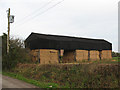
Hay barn at Grange Farm
A timber framed barn, nearly full of hay at the end of October.
Image: © Stephen Craven
Taken: 31 Oct 2009
0.07 miles
2
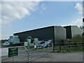
Metal sheds alongside Davenport Park Lane
A sign says there's a business called D & S Sheard based here. They are described elsewhere as "agricultural contractors". The metal sheds have replaced a previous 'dutch' barn Image
Image: © Stephen Craven
Taken: 17 Apr 2021
0.09 miles
3
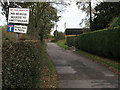
SatNav warning near Swettenham
The sign is at the turning off the A54 near Holmes Chapel, into Davenport Park Lane, a gated private road that (physically speaking) does give access to Swettenham - presumably the software supplied with some navigations systems takes it to be a public road.
Image: © Stephen Craven
Taken: 31 Oct 2009
0.12 miles
4
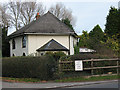
Davenport Lodge
The lodge stands adjacent to the A54 between Congleton and Holmes Chapel. It relates to Davenport Hall, a little off the main road to the north.
Image: © Stephen Craven
Taken: 31 Oct 2009
0.13 miles
5
Cross Mere Farm
Viewed from Brereton Heath nature reserve nearby.
Image: © Stephen Craven
Taken: 29 Dec 2015
0.17 miles
6
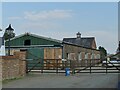
Stables at Cross Mere Farm
The farm Image is a riding centre.
Image: © Stephen Craven
Taken: 17 Apr 2021
0.17 miles
7
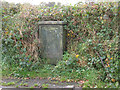
Lucy Pillar in a hedgerow
This "lucy" pillar is marked GPO (General Post Office) and looks as if has not been painted for decades, indeed may no longer be in use.
Image: © Stephen Craven
Taken: 31 Oct 2009
0.19 miles
8
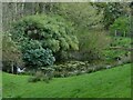
Heron taking off
The heron had been standing at the side of one of a cascade of four ponds (see also Image).
Image: © Stephen Craven
Taken: 17 Apr 2021
0.20 miles
9
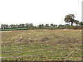
Stubble in a field off Davenport Lane
It would probably not be long after this (end of October) that the stubble would be ploughed in ready for planting next year's crop.
Image: © Stephen Craven
Taken: 31 Oct 2009
0.20 miles
10
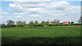
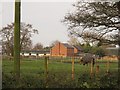
Crossmere Farm
Looking over the fields towards Crossmere Farm from the northern boundary of Brereton Heath Country Park. Crossmere Farm is situated at the junction of the A54, Holmes Chapel Road, and Davenport Lane which is on the other side of the fence on the left of the picture.
Image: © Jonathan Kington
Taken: 4 May 2010
0.22 miles