IMAGES TAKEN NEAR TO
Holmes Chapel Road, CONGLETON, CW12 4SN
Introduction
This page details the photographs taken nearby to Holmes Chapel Road, CW12 4SN by members of the Geograph project.
The Geograph project started in 2005 with the aim of publishing, organising and preserving representative images for every square kilometre of Great Britain, Ireland and the Isle of Man.

There are currently over 7.5m images from over14,400 individuals and you can help contribute to the project by visiting https://www.geograph.org.uk
Image Map
Images are licensed for reuse under creativecommons.org/licenses/by-sa/2.0
Notes
- Clicking on the map will re-center to the selected point.
- The higher the marker number, the further away the image location is from the centre of the postcode.
Image Listing (6 Images Found)
Images are licensed for reuse under creativecommons.org/licenses/by-sa/2.0
Image
Details
Distance
1
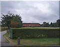
Somerford Farm, Brereton
The barns at Somerford Farm have been converted to a Business Centre.
Image: © Eirian Evans
Taken: 31 Jul 2006
0.08 miles
2
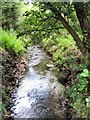
Loach Brook
Loach Brook flows through Pool Wood in Somerford on its way to the River Dane.
Image: © David C Brown
Taken: 28 Jul 2007
0.15 miles
3
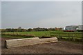
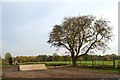
Somerford Park Farm Ride (4)
A pair of rolltops of different heights.
Image: © Jonathan Hutchins
Taken: 31 Oct 2015
0.20 miles
6
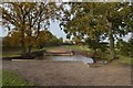
Somerford Park Farm Ride (3)
Optional water obstacle.
Image: © Jonathan Hutchins
Taken: 31 Oct 2015
0.24 miles