IMAGES TAKEN NEAR TO
Broomfields, CONGLETON, CW12 4SG
Introduction
This page details the photographs taken nearby to Broomfields, CW12 4SG by members of the Geograph project.
The Geograph project started in 2005 with the aim of publishing, organising and preserving representative images for every square kilometre of Great Britain, Ireland and the Isle of Man.

There are currently over 7.5m images from over14,400 individuals and you can help contribute to the project by visiting https://www.geograph.org.uk
Image Map
Images are licensed for reuse under creativecommons.org/licenses/by-sa/2.0
Notes
- Clicking on the map will re-center to the selected point.
- The higher the marker number, the further away the image location is from the centre of the postcode.
Image Listing (14 Images Found)
Images are licensed for reuse under creativecommons.org/licenses/by-sa/2.0
Image
Details
Distance
1
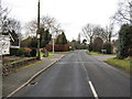
Brereton Heath Lane
Looking up the lane from near the junction of the A52.
Image: © Jonathan Kington
Taken: 9 Feb 2010
0.10 miles
3
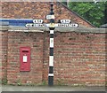
Old Direction Sign - Signpost by the A54, Holmes Chapel Road, Brereton parish
Pawn finial - 3 arms; Cheshire CCC octagonal by the A54, in parish of Brereton (Congleton District), junction of Holmes Chapel Road with Brereton Heath Lane. N.B. The postbox is no longer there.
To be surveyed
Milestone Society National ID: CH_SJ8064
Image: © Milestone Society
Taken: Unknown
0.13 miles
4

Direction Sign - Signpost on Holmes Chapel Road
Located on the northeast side of the junction of the A54 Holmes Chapel Road and Brereton Heath Lane. Brereton parish. 3 arms and pawn finial. See also https://www.geograph.org.uk/photo/6051268 , http://www.flickr.com/photos/21940361@N08/4963675753/ and http://www.geograph.org.uk/photo/1700089.
Milestone Society National ID: CH_SJ8064
Image: © J Hulme
Taken: 1 Oct 2025
0.13 miles
5
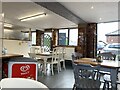
Inside G Gee's cafe
G Gee's is the on-site cafe for Somerford Park Farm, a large equestrian facility between Congleton and Holmes Chapel.
Image: © Jonathan Hutchins
Taken: 22 Oct 2021
0.13 miles
6
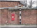
Signpost, Brereton Heath
These old-style "fingerposts" are becoming very rare now, presumably this one on the junction of the A54 and Brereton Heath Lane has been retained by popular demand. The letters CCC can be made out on the post- these stand for the, now defunct, Cheshire County Council; since April 1st 2009 it has been known as Cheshire East Council.
Image: © Jonathan Kington
Taken: 9 Feb 2010
0.14 miles
7
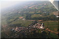
Somerford Park Equestrian Centre: aerial 2015
Image: © Chris
Taken: 2 Oct 2015
0.16 miles
8
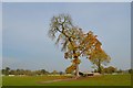
Somerford Park Farm: tree in cross-country school
Image: © Jonathan Hutchins
Taken: 31 Oct 2015
0.17 miles
9
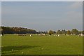
Somerford Park Farm: cross-country school
Image: © Jonathan Hutchins
Taken: 31 Oct 2015
0.19 miles