IMAGES TAKEN NEAR TO
Amsom Close, CW12 4QE
Introduction
This page details the photographs taken nearby to Amsom Close, CW12 4QE by members of the Geograph project.
The Geograph project started in 2005 with the aim of publishing, organising and preserving representative images for every square kilometre of Great Britain, Ireland and the Isle of Man.

There are currently over 7.5m images from over14,400 individuals and you can help contribute to the project by visiting https://www.geograph.org.uk
Image Map
Images are licensed for reuse under creativecommons.org/licenses/by-sa/2.0
Notes
- Clicking on the map will re-center to the selected point.
- The higher the marker number, the further away the image location is from the centre of the postcode.
Image Listing (3 Images Found)
Images are licensed for reuse under creativecommons.org/licenses/by-sa/2.0
Image
Details
Distance
2
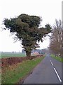
Ivy clad tree, Black Firs Lane
Even a tree as clothed with ivy as this one will not die from the overgrowth, but the weight and density of the evergreen creeper make the host tree vulnerable to being blown over in winter storms. Black Firs Lane leads into West Heath, Congleton.
Image: © Richard Dorrell
Taken: 13 Mar 2012
0.22 miles
3
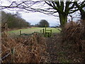
Footpath west of Radnor Hall Farm
This footpath runs from Radnor Bridge to the farm access road to Radnor Hall Farm.
Image: © Colin Park
Taken: 16 Jan 2006
0.23 miles