IMAGES TAKEN NEAR TO
Moss Close, CONGLETON, CW12 3UG
Introduction
This page details the photographs taken nearby to Moss Close, CW12 3UG by members of the Geograph project.
The Geograph project started in 2005 with the aim of publishing, organising and preserving representative images for every square kilometre of Great Britain, Ireland and the Isle of Man.

There are currently over 7.5m images from over14,400 individuals and you can help contribute to the project by visiting https://www.geograph.org.uk
Image Map
Images are licensed for reuse under creativecommons.org/licenses/by-sa/2.0
Notes
- Clicking on the map will re-center to the selected point.
- The higher the marker number, the further away the image location is from the centre of the postcode.
Image Listing (76 Images Found)
Images are licensed for reuse under creativecommons.org/licenses/by-sa/2.0
Image
Details
Distance
1

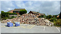
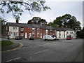
The Moss Inn, Canal Street, Congleton
Despite expanding into a pub/restaurant this excellent hostelry, brilliantly and expertly run by Jim and Ann for a quarter of a century in the most friendly and welcoming manner, continues to serve real ale and remains a true "local". Let's hope their retirement does not lead to lowering of standards.
Update 6 October 2009: Ann and Jim retired on 24 August 2009. Kyla invites everybody to visit the Moss Inn to enjoy the new menu in the recently updated decor. Sounds good to me :-)
Update November 2014. The pub was demolished earlier this year.
Image: © Roger D Kidd
Taken: 28 Aug 2007
0.01 miles
2
The ex-Moss Inn at Congleton, Cheshire
This was a friendly and well run pub in the 1990s and until Ann and Jim retired in 2009. It was refurbished in about 2011, but that didn't do it any good!!
Image]
Image: © Roger D Kidd
Taken: 4 Sep 2014
0.01 miles
3
The ex-Moss Inn at Congleton, Cheshire
In Canal Road, this was a friendly and well run pub in the 1990s and through until Ann and Jim retired in 2009. It was refurbished in about 2011, but that didn't do it any good!! Marston's must have fancied the cash for the site.
Image]
Image: © Roger D Kidd
Taken: 4 Sep 2014
0.01 miles
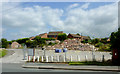
4
The Moss
Pub located near the railway bridge in Mossley, storm clouds were gathering behind. For a close-up of the sign see Image
Update: The pub was demolished in 2014, see Roger Kidd's picture Image .
Image: © Jonathan Kington
Taken: 21 Aug 2011
0.01 miles
5
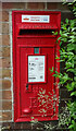
Elizabeth II postbox on Canal Road, Congleton
Postbox No. CW12 17.
Image: © JThomas
Taken: 30 May 2024
0.03 miles
6
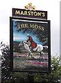
Sign for The Moss
Located by the entrance to the car-park for Image, the sign depicts a highwayman galloping across heather moorland. According to David Iredale in "A History of Congleton", Edited by W. B. Stephens ( http://tinyurl.com/3g69jom ), in the 18th century this area was a wilderness of moorland and common pasture land. These common lands provided a useful supply of timber and grazing for animals, they also provided a good area for highwaymen and vagabonds to hide in.
Image: © Jonathan Kington
Taken: 21 Aug 2011
0.03 miles
7
Spar shop
A handy little supermarket in a terrace of cottages in Mossley.
Image: © Jonathan Kington
Taken: 21 Aug 2011
0.03 miles
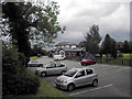
8
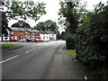
North end of Astbury Lane Ends, Congleton
Seen from Canal Road, which it has been bent to meet here. The houses and shops appear to have fronted onto the road's old alignment, which is now used for car parking.
Image: © Richard Vince
Taken: 1 Jun 2019
0.03 miles
9
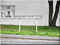
Sign for Astbury Lane Ends
Located at the junction of Astbury Lane Ends and Canal Road in Mossley (Image).
Image: © Jonathan Kington
Taken: 21 Aug 2011
0.04 miles
10
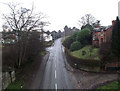
Looking up Canal Road
Looking off Dog Lane aqueduct and up Canal Road towards Mossley, the name Dog Lane comes from a small road leading up to the canal- the junction of which is visible in the right foreground.
Image: © Jonathan Kington
Taken: 15 Dec 2010
0.05 miles