IMAGES TAKEN NEAR TO
Key Green, CONGLETON, CW12 3PY
Introduction
This page details the photographs taken nearby to Key Green, CW12 3PY by members of the Geograph project.
The Geograph project started in 2005 with the aim of publishing, organising and preserving representative images for every square kilometre of Great Britain, Ireland and the Isle of Man.

There are currently over 7.5m images from over14,400 individuals and you can help contribute to the project by visiting https://www.geograph.org.uk
Image Map
Images are licensed for reuse under creativecommons.org/licenses/by-sa/2.0
Notes
- Clicking on the map will re-center to the selected point.
- The higher the marker number, the further away the image location is from the centre of the postcode.
Image Listing (4 Images Found)
Images are licensed for reuse under creativecommons.org/licenses/by-sa/2.0
Image
Details
Distance
1
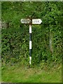
Fingerpost at Key Green
A 'modern' (i.e. post-cast-iron) version with cast aluminium fingers.
Image: © Alan Murray-Rust
Taken: 9 Aug 2016
0.01 miles
2
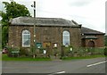
Key Green Methodist Chapel
Built of gritstone and dated 1845. The entrance is unusually sited in the middle of the side wall. The schoolroom to the right was added in 1923.
Unlike so many rural chapels, this one is still a functioning place of worship.
Image: © Alan Murray-Rust
Taken: 9 Aug 2016
0.03 miles
3
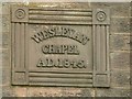
Key Green Methodist Chapel
Datestone above the main entrance. See http://www.geograph.org.uk/photo/5076287 for location.
Image: © Alan Murray-Rust
Taken: 9 Aug 2016
0.03 miles
4
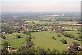
Key Green, Cheshire
Fields sloping down from The Cloud to the hamlet of Key Green. Key Green Methodist Church is the brick building in an enclosed part of the big field. In the distance above is Eaton Hall sand quarry Image, at two o'clock from which is the Jodrell Bank Radio Telescope Image in the sub-horizon haze.
Image: © John Robinson
Taken: 2 May 2007
0.09 miles