IMAGES TAKEN NEAR TO
Whitemore, CONGLETON, CW12 3NE
Introduction
This page details the photographs taken nearby to CW12 3NE by members of the Geograph project.
The Geograph project started in 2005 with the aim of publishing, organising and preserving representative images for every square kilometre of Great Britain, Ireland and the Isle of Man.

There are currently over 7.5m images from over14,400 individuals and you can help contribute to the project by visiting https://www.geograph.org.uk
Image Map
Images are licensed for reuse under creativecommons.org/licenses/by-sa/2.0
Notes
- Clicking on the map will re-center to the selected point.
- The higher the marker number, the further away the image location is from the centre of the postcode.
Image Listing (37 Images Found)
Images are licensed for reuse under creativecommons.org/licenses/by-sa/2.0
Image
Details
Distance
1
Starting to look its age
This old West Midlands Gas Company's marker post has spent so long beside the Biddulph Valley Way that it has grown a mossy hairpiece and beard! The company will have been merged with other companies several times over by now, it is probably called Transco or National Grid (Gas) now.
Image: © Jonathan Kington
Taken: 10 Nov 2010
0.04 miles
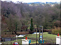
2
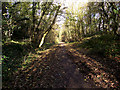
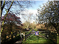
Bordered by embankments
Just north of the location of the Image and the Biddulph Valley Way passes through a cutting, a quiet and peaceful stretch with the noise of the traffic on the main road muted. The trail was created using a disused railway line and has proved very popular with walkers, cyclists and horse riders.
Image: © Jonathan Kington
Taken: 10 Nov 2010
0.06 miles
3
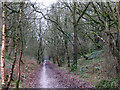
Cutting on the Biddulph Valley Way
This cutting was originally made for the Biddulph Valley Railway (1859 to 1968). It is now a recreational route and the cutting forms part of the Whitemore Local Nature Reserve.
Image: © Stephen Craven
Taken: 30 Dec 2010
0.07 miles
4
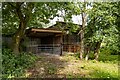
Biddulph Valley Way
Farm buildings alongside the Biddulph Valley Way.
Image: © Peter McDermott
Taken: 13 Jul 2023
0.07 miles
5
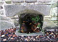
Old well
Built into a garden wall beside Biddulph Road is this piped spring running into a stone trough that is not marked on the map, the water was crystal clear coming out of the pipe and the lintel stone has obviously been carved so as to allow horses access to drink.
Image: © Jonathan Kington
Taken: 10 Nov 2010
0.09 miles
6
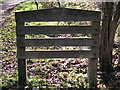
Entering Cheshire
This gate, on the Biddulph Valley Way, marks the county boundary between Staffordshire and Cheshire. It also marks the change from Staffordshire Moorlands District Council and Cheshire East Council, a fairly recently formed district council that incorporated the former Congleton Borough Council.
Image: © Jonathan Kington
Taken: 10 Nov 2010
0.10 miles
7
Looking back into Staffordshire
This rather scruffy, tired looking sign (especially when compared with the signs in Image) on the Biddulph Valley Way marks the border between Cheshire and Staffordshire. It also marks the northern boundary of Whitemore Local Nature Reserve (Image).
Image: © Jonathan Kington
Taken: 10 Nov 2010
0.10 miles
8
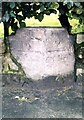
Old Milestone by the A527, Whitemoor, BiddulphParish
Carved stone post by the A527, in parish of BIDDULPH (STAFFORDSHIRE MOORLANDS District), Whitemoor near County Boundary, in low wall, on West side of road. Newcastle triangle stone, erected by the New Biddulph turnpike trust in the 19th century. Defaced.
Inscription reads:- : TO / Congleton / 1 Mile : : TO / Newcastle / 11 / Miles :
Milestone Society National ID: ST_NCCO11.
Image: © J Higgins
Taken: 1 Jan 2000
0.11 miles
9
Two small weirs on the Biddulph Brook
A pair of weirs viewed from the Biddulph Valley Way.
Image: © Stephen Craven
Taken: 30 Dec 2010
0.11 miles
10
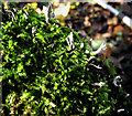
Candle Snuff Fungi
Growing amongst the moss on an old tree stump (Image) next to the Biddulph Valley Way in Whitemore Nature Reserve is some Candle Snuff Fungus (Xylaria hypoxylon). It is a common fungus that can be found at any time of the year; the common name is meant to describe its likeness to a snuffed-out candle wick. The scientific name comes from the Greek for 'wooden' which refers to the texture of the fungus.
Image: © Jonathan Kington
Taken: 10 Nov 2010
0.11 miles