IMAGES TAKEN NEAR TO
Congleton Edge, CONGLETON, CW12 3NB
Introduction
This page details the photographs taken nearby to Congleton Edge, CW12 3NB by members of the Geograph project.
The Geograph project started in 2005 with the aim of publishing, organising and preserving representative images for every square kilometre of Great Britain, Ireland and the Isle of Man.

There are currently over 7.5m images from over14,400 individuals and you can help contribute to the project by visiting https://www.geograph.org.uk
Image Map
Images are licensed for reuse under creativecommons.org/licenses/by-sa/2.0
Notes
- Clicking on the map will re-center to the selected point.
- The higher the marker number, the further away the image location is from the centre of the postcode.
Image Listing (60 Images Found)
Images are licensed for reuse under creativecommons.org/licenses/by-sa/2.0
Image
Details
Distance
1
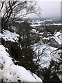
Nick I' th' Hill from Congleton Edge
Image: © Philip Cornwall
Taken: 1 Jan 2021
0.01 miles
2
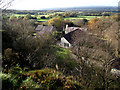
Looking onto the roofs
Although the northern half of this gritstone ridge is called Congleton Edge there is also a small community of houses that go by the same name. This picture is looking down from the public footpath onto the tops of some of those houses.
Image: © Jonathan Kington
Taken: 10 Nov 2010
0.01 miles
4
Tight fit
With very limited room for turning round in Congleton Edge and Nick i' th' Hill, the refuse wagon has to reverse for about quarter of a mile to service the last houses on this road.
Image: © Jonathan Kington
Taken: 10 Nov 2010
0.01 miles
5
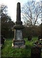
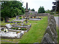
Congleton Edge War Memorial
Located in the tiny graveyard attached to Image, this memorial is a poignant reminder that there were probably no communities in Britain and Ireland untouched by World War I. There are five names inscribed on the panels, this may not seem many until it is put in context- Congleton Edge is a tiny community that is hardly big enough to call a hamlet and to lose five able-bodied men in one go must have been devastating, affecting all the households in one way or another.
Image: © Jonathan Kington
Taken: 10 Nov 2010
0.02 miles
6
Wesleyan Chapel Date Stone
on the present Congleton Edge Methodist Church.
Image: © Neil Lewin
Taken: 8 Jun 2007
0.02 miles
7
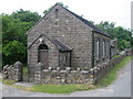
Congleton Edge Methodist Church
Built in 1833 and rebuilt in 1889.
Image: © Neil Lewin
Taken: 8 Jun 2007
0.02 miles
8

Congleton Edge Methodist Chapel
First built in 1883 as a Wesleyan Chapel, it was then rebuilt in 1889. It is still very much in use having been refurbished in recent years with new toilets, central heating and a kitchen area added. They are trying very hard to keep this chapel going - hoping that it will become a popular venue for weddings and other Christian social events ( http://www.congletonmethodist.org.uk/ourchurches/ourchurches_subpages/congleton_edge_background.htm ), it is certainly in a very lovely location. Just past the third window is a benchmark pictured in Image For a similar view taken in 2007 see Image taken by Neil Lewin, very little has changed!
Image: © Jonathan Kington
Taken: 10 Nov 2010
0.02 miles
9
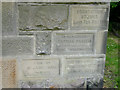
Foundation Stones
on the Congleton Edge Methodist Chapel. As they are dated 1929 I presume that these are for an extension of the original chapel.
Image: © Neil Lewin
Taken: 8 Jun 2007
0.02 miles
10

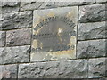
Benchmark on Congleton Edge Chapel
This cut mark is carved on the eastern wall of Image The Ordnance Survey benchmarks were used by engineers to obtain an accurate elevation above sea-level before the advent of GPS. For more information on this and other bench marks visit http://www.bench-marks.org.uk/bm36011
Image: © Jonathan Kington
Taken: 10 Nov 2010
0.03 miles