IMAGES TAKEN NEAR TO
Reades Lane, CONGLETON, CW12 3LL
Introduction
This page details the photographs taken nearby to Reades Lane, CW12 3LL by members of the Geograph project.
The Geograph project started in 2005 with the aim of publishing, organising and preserving representative images for every square kilometre of Great Britain, Ireland and the Isle of Man.

There are currently over 7.5m images from over14,400 individuals and you can help contribute to the project by visiting https://www.geograph.org.uk
Image Map
Images are licensed for reuse under creativecommons.org/licenses/by-sa/2.0
Notes
- Clicking on the map will re-center to the selected point.
- The higher the marker number, the further away the image location is from the centre of the postcode.
Image Listing (28 Images Found)
Images are licensed for reuse under creativecommons.org/licenses/by-sa/2.0
Image
Details
Distance
1
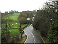
Looking off the bridge
Looking from Image along the road towards Mossley, part of Congleton Golf Club is on the left.
Image: © Jonathan Kington
Taken: 17 Nov 2010
0.14 miles
3
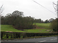
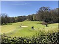
Congleton Golf Club
The course occupies the land between the A52 and the Biddulph Valley Way.
Image: © Stephen Craven
Taken: 30 Dec 2010
0.15 miles
4
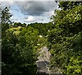
Reade's Lane
Reade's Lane seen from the Biddulph Valley Way.
Image: © Peter McDermott
Taken: 13 Jul 2023
0.16 miles
5
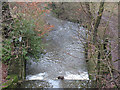
Weir on the Biddulph Brook
The weir, immediately downstream of Reade's Lane, was originally fitted with sluice gates. I presume it was part of the water system feeding nearby Martin Mill.
Image: © Stephen Craven
Taken: 30 Dec 2010
0.17 miles
6
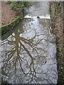
Reflected tree
The bare tree was reflected in the somewhat muddy waters of the Biddulph Brook, with a calm surface being immediately behind a weir Image
Image: © Stephen Craven
Taken: 30 Dec 2010
0.17 miles
7
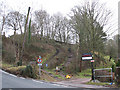
Steps up to the Biddulph Valley Way
There are two sets of steps: I presume the steeper ones are intended for walkers and the shallower ones for horse riders. The sign banning motor vehicles should be unnecessary, but perhaps motorcyclists have managed to get their machines up here in the past.
Image: © Stephen Craven
Taken: 30 Dec 2010
0.18 miles
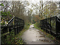
8
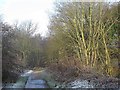
Biddulph Valley Trail at Dane-in-Shaw
Looking north.
Image: © Stephen Craven
Taken: 29 Dec 2014
0.19 miles
9
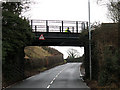
Bridge on the Biddulph Valley Way
This bridge originally carried the Biddulph Valley Railway (1859 to 1968). It is now a recreational route as can be seen by the cyclist crossing the bridge.
The height of the bridge over Reade's Lane is 12 feet (unusually nowadays, the metric equivalent is not given).
For a view on top of the bridge see Image
Image: © Stephen Craven
Taken: 30 Dec 2010
0.19 miles
10
Higher Dane in Shaw Bridge
This bridge carries the former railway line that is now the Biddulph Valley Way over the road between Mossley and Rainow.
Image: © Jonathan Kington
Taken: 17 Nov 2010
0.19 miles