IMAGES TAKEN NEAR TO
Park Lane, CONGLETON, CW12 3DD
Introduction
This page details the photographs taken nearby to Park Lane, CW12 3DD by members of the Geograph project.
The Geograph project started in 2005 with the aim of publishing, organising and preserving representative images for every square kilometre of Great Britain, Ireland and the Isle of Man.

There are currently over 7.5m images from over14,400 individuals and you can help contribute to the project by visiting https://www.geograph.org.uk
Image Map
Images are licensed for reuse under creativecommons.org/licenses/by-sa/2.0
Notes
- Clicking on the map will re-center to the selected point.
- The higher the marker number, the further away the image location is from the centre of the postcode.
Image Listing (69 Images Found)
Images are licensed for reuse under creativecommons.org/licenses/by-sa/2.0
Image
Details
Distance
1
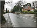
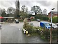
Park Lane A527 at junction with Copthorne Close, Congleton
Image: © Jonathan Hutchins
Taken: 18 Mar 2017
0.11 miles
2
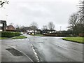
Road junction in suburban Congleton
Image: © Jonathan Hutchins
Taken: 18 Mar 2017
0.14 miles
3
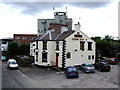
Queens Head, Congleton
The canal aspect and a ray of sunshine would do more justice to this interesting pub opposite the rail station. The beer range, up to seven real beers, makes this a must visit pub for boaters and others alike.
Image: © al partington
Taken: 23 May 2007
0.14 miles
5
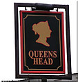
Sign for the Queens Head
This is the sign for the Image It is a very popular name for a public house and the sign often carries a silhouette of a head which could refer to number of different queens, but, due to an unwritten rule, it will never be the likeness of the current reigning monarch.
Image: © Jonathan Kington
Taken: 15 Dec 2010
0.14 miles
6
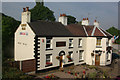
The Queen's Head, Congleton
This pub is conveniently placed for both the Macclesfield Canal and Congleton's railway station in the Hightown district.
Image: © Stephen McKay
Taken: 2 Sep 2010
0.15 miles
7
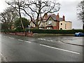
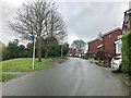
Park Lane A527 at junction with Highcroft Avenue, Congleton
Image: © Jonathan Hutchins
Taken: 18 Mar 2017
0.16 miles
9
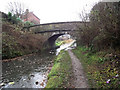
Bridge 76, Morris Bridge
Now carrying a footpath over the Macclesfield Canal, Bridge 76 was originally built to allow the horses towing the narrowboats to cross from one side to another without having to release the tow rope (Image).
The Macclesfield Canal was one of the last narrow canals to be built and runs approximately 28 miles from Harding's Wood Junction on the Trent and Mersey Canal, along the edge of the western Pennine hills to Marple Junction on the Peak Forest Canal. It was surveyed by Thomas Telford with construction starting in 1826, with William Crosley doing the engineering. The canal opened in November 1831 having cost a total of £320,000.
Image: © Jonathan Kington
Taken: 15 Dec 2010
0.16 miles
10
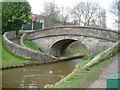
Snake Bridge no 76, Macclesfield Canal
These distinctive bridges allowed the towpath to cross the canal without the horse being unhitched from the narrowboat it was pulling.
Image: © Ray Folwell
Taken: 29 Mar 2008
0.16 miles