IMAGES TAKEN NEAR TO
Sandy Lane, CONGLETON, CW12 2LN
Introduction
This page details the photographs taken nearby to Sandy Lane, CW12 2LN by members of the Geograph project.
The Geograph project started in 2005 with the aim of publishing, organising and preserving representative images for every square kilometre of Great Britain, Ireland and the Isle of Man.

There are currently over 7.5m images from over14,400 individuals and you can help contribute to the project by visiting https://www.geograph.org.uk
Image Map
Images are licensed for reuse under creativecommons.org/licenses/by-sa/2.0
Notes
- Clicking on the map will re-center to the selected point.
- The higher the marker number, the further away the image location is from the centre of the postcode.
Image Listing (4 Images Found)
Images are licensed for reuse under creativecommons.org/licenses/by-sa/2.0
Image
Details
Distance
1
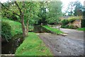
Swettenham Ford
This ford at Swettenham is truly impressive and at the time of my visit, after two days of heavy rain, was passable by all.
Image: © John Walton
Taken: 12 Oct 2013
0.04 miles
2
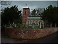
St Peters Church, Swettenham
St Peters Church, Swettenham. It is said that an underground passage links the church with the nearby Swettenham Arms. The latter was once a nunnery.
Image: © Colin Park
Taken: 16 Jan 2006
0.10 miles
3
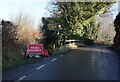
Sandy Lane closed to traffic
Off Swettenham Lane, Swettenham.
Image: © Ian S
Taken: 5 Jan 2022
0.11 miles
4
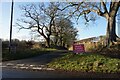
Sandy Lane closed to traffic
Taken from Swettenham Road.
Image: © Ian S
Taken: 5 Jan 2022
0.16 miles