IMAGES TAKEN NEAR TO
South Street, CONGLETON, CW12 1HH
Introduction
This page details the photographs taken nearby to South Street, CW12 1HH by members of the Geograph project.
The Geograph project started in 2005 with the aim of publishing, organising and preserving representative images for every square kilometre of Great Britain, Ireland and the Isle of Man.

There are currently over 7.5m images from over14,400 individuals and you can help contribute to the project by visiting https://www.geograph.org.uk
Image Map
Images are licensed for reuse under creativecommons.org/licenses/by-sa/2.0
Notes
- Clicking on the map will re-center to the selected point.
- The higher the marker number, the further away the image location is from the centre of the postcode.
Image Listing (138 Images Found)
Images are licensed for reuse under creativecommons.org/licenses/by-sa/2.0
Image
Details
Distance
1
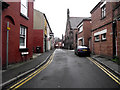
Cross Street
Looking along Cross Street from its junction with Mill Street, the Image is about halfway along on the right.
Image: © Jonathan Kington
Taken: 20 Mar 2011
0.02 miles
2
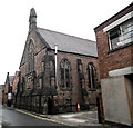
Pentecostal Chapel
This lovely building on Cross Street was built in 1883 using stone pink sandstone from Teggs Nose Quarry near Macclesfield. For a picture of the front see Image
Image: © Jonathan Kington
Taken: 20 Mar 2011
0.03 miles
3
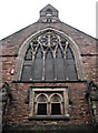
Front of the chapel
The Pentecostal Chapel was built in 1883 using pink sandstone from Teggs Nose Quarry near Macclesfield. Cross Street is very narrow making it difficult to get a shot of the full front. (See also Image).
Image: © Jonathan Kington
Taken: 20 Mar 2011
0.03 miles
4
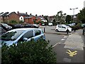
Antrobus Street car park, Congleton
A relatively cheap pay-and-display facility, handy for the town centre shops.
Image: © Stephen Craven
Taken: 14 Aug 2021
0.03 miles
5
Bon-O-Phool
Located on the corner of Mill Street and Antrobus Street, Bon-O-Phool is an Indian restaurant and take-away. The rear of the Image on Cross Street is visible too.
Image: © Jonathan Kington
Taken: 20 Mar 2011
0.04 miles
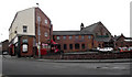
6
The Bull's Head, Congleton
The pub was converted from an 18th century and is grade II listed (list entry 1130471). See Image for a view in 2010. The building beyond it is the former post office.
Image: © Stephen Craven
Taken: 14 Aug 2021
0.05 miles
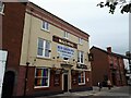
7

The Bulls Head
Located at the bottom of Swan Bank, the Bulls Head is a Hydes of Manchester public house. It appears to be an hotel with an extensive function suite adjacent to it at the rear that can be used for weddings and corporate events. For a close-up of the sign see Image
Image: © Jonathan Kington
Taken: 15 Dec 2010
0.05 miles
8

Sign for the Bulls Head
This is the sign attached to Image The Bulls Head is a very popular sign stemming from when illiteracy was rife, it is an easily recognisable emblem. It may also have its roots in Roman Catholicism from "bulla", a large seal that was attached to important Papal documents.
Image: © Jonathan Kington
Taken: 15 Dec 2010
0.05 miles
9
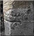
Bench mark on The Counting House
This cut mark is on the corner of Image, it looks very much like somebody has tried to destroy it. For more information on this and other bench marks go to http://www.bench-marks.org.uk/bm36318 .
Image: © Jonathan Kington
Taken: 15 Dec 2010
0.06 miles
10
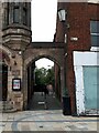
Footpath from Mill Street to Antrobus Street
The path connects the shopping streets with a car park.
Image: © Stephen Craven
Taken: 14 Aug 2021
0.06 miles