IMAGES TAKEN NEAR TO
Roughwood, SANDBACH, CW11 4XX
Introduction
This page details the photographs taken nearby to Roughwood, CW11 4XX by members of the Geograph project.
The Geograph project started in 2005 with the aim of publishing, organising and preserving representative images for every square kilometre of Great Britain, Ireland and the Isle of Man.

There are currently over 7.5m images from over14,400 individuals and you can help contribute to the project by visiting https://www.geograph.org.uk
Image Map
Images are licensed for reuse under creativecommons.org/licenses/by-sa/2.0
Notes
- Clicking on the map will re-center to the selected point.
- The higher the marker number, the further away the image location is from the centre of the postcode.
Image Listing (22 Images Found)
Images are licensed for reuse under creativecommons.org/licenses/by-sa/2.0
Image
Details
Distance
2
The Salt Line crossing a minor road
A section of a disused railway line north of Alsager, now in use as a footpath. The route is known as the Salt Line and is part of the Wheelock Branch line which as a railway carried salt and other goods from Cheshire to the Potteries; coal travelled the other way.
Image: © Trevor Littlewood
Taken: 22 Dec 2022
0.11 miles
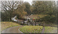
3
The Salt Line crosses a minor road
There would have been a bridge here but it has long gone, so walkers on the Salt Line trail have to descend to the road and up the other side.
Image: © Stephen Craven
Taken: 24 Dec 2014
0.11 miles
5
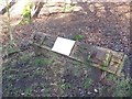
Former railway sleeper
Now used as a backing board for an informational plaque for the Salt Line Trail.
Image: © Stephen Craven
Taken: 24 Dec 2014
0.15 miles
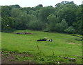
6
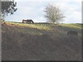
Ponies on a former railway embankment
Viewed from what is now the Salt Line Trail.
Image: © Stephen Craven
Taken: 24 Dec 2014
0.16 miles
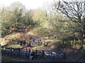
7
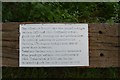
Plaque on Salt Line Trail
This descriptive plaque is mounted on a railway sleeper alongside the Trail (see http://www.geograph.org.uk/photo/4296242 ). The paint on most of the letters has worn so that they are as white as the background.
Transcription:
The Wheelock Branch Line was opened in stages
between 1852 and 1858. Originally it was a
goods line only, carrying salt and products from
the chemical industries in Cheshire to the
Potteries. The wagons brought back coal to
power these industries.
Trentham Gardens was a favourite destination
when passenger services were introduced in
1893. These ended in 1930 and the line
remained a goods line until it closed in 1970.
Image: © Jonathan Hutchins
Taken: 12 Jul 2015
0.16 miles
8
Trent & Mersey Canal Milepost near Hassall Green
Along the towpath next to Rough Wood Bridge No 146.
Image, for the previous milepost.
Image, for the next milepost along the canal.
Image: © Mat Fascione
Taken: 11 Jul 2015
0.18 miles

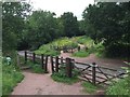
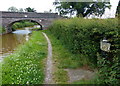
10
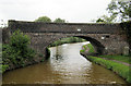
Bridge 146
Trent and Mersey Canal between lock 56 and Hassall Green
Image: © Mike Todd
Taken: 12 May 2011
0.19 miles