IMAGES TAKEN NEAR TO
Hassall, SANDBACH, CW11 4SE
Introduction
This page details the photographs taken nearby to CW11 4SE by members of the Geograph project.
The Geograph project started in 2005 with the aim of publishing, organising and preserving representative images for every square kilometre of Great Britain, Ireland and the Isle of Man.

There are currently over 7.5m images from over14,400 individuals and you can help contribute to the project by visiting https://www.geograph.org.uk
Image Map
Images are licensed for reuse under creativecommons.org/licenses/by-sa/2.0
Notes
- Clicking on the map will re-center to the selected point.
- The higher the marker number, the further away the image location is from the centre of the postcode.
Image Listing (5 Images Found)
Images are licensed for reuse under creativecommons.org/licenses/by-sa/2.0
Image
Details
Distance
1
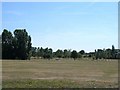
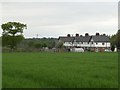
Malkin's Bank Golf Course
View from the footpath of the Trent and Mersey Canal across the golf course. Hassall House Farm can be seen in the distance.
Image: © Steve Lewin
Taken: 24 Jul 2006
0.06 miles
3
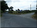
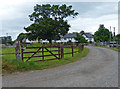
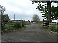
Mill Lane at junction to Hassall Moss farm
Image: © Colin Pyle
Taken: 10 Jul 2010
0.15 miles