IMAGES TAKEN NEAR TO
Alsager Road, SANDBACH, CW11 4SA
Introduction
This page details the photographs taken nearby to Alsager Road, CW11 4SA by members of the Geograph project.
The Geograph project started in 2005 with the aim of publishing, organising and preserving representative images for every square kilometre of Great Britain, Ireland and the Isle of Man.

There are currently over 7.5m images from over14,400 individuals and you can help contribute to the project by visiting https://www.geograph.org.uk
Image Map (Loading...)


Getting Data...Please wait
Leaflet Map data © OpenStreetMap
Images are licensed for reuse under creativecommons.org/licenses/by-sa/2.0
Notes
- Clicking on the map will re-center to the selected point.
- The higher the marker number, the further away the image location is from the centre of the postcode.
Image Listing (4 Images Found)
Images are licensed for reuse under creativecommons.org/licenses/by-sa/2.0
Image
Details
Distance
3
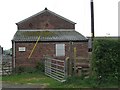
South Cheshire Way at School Farm
At this point the South Cheshire Way follows the road for only 50m or so before heading off down the side of the farm buildings.
Image: © Steve Lewin
Taken: 24 Apr 2007
0.06 miles
4
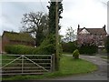
Walnut Tree Farm
Note the rather interesting "green roof" on the building on the left.
Image: © Steve Lewin
Taken: 24 Apr 2007
0.08 miles