IMAGES TAKEN NEAR TO
Third Avenue, SANDBACH, CW11 4PF
Introduction
This page details the photographs taken nearby to Third Avenue, CW11 4PF by members of the Geograph project.
The Geograph project started in 2005 with the aim of publishing, organising and preserving representative images for every square kilometre of Great Britain, Ireland and the Isle of Man.

There are currently over 7.5m images from over14,400 individuals and you can help contribute to the project by visiting https://www.geograph.org.uk
Image Map
Images are licensed for reuse under creativecommons.org/licenses/by-sa/2.0
Notes
- Clicking on the map will re-center to the selected point.
- The higher the marker number, the further away the image location is from the centre of the postcode.
Image Listing (26 Images Found)
Images are licensed for reuse under creativecommons.org/licenses/by-sa/2.0
Image
Details
Distance
1
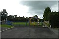
Newall Avenue Playground
A small park in a residential area of Sandbach.
Image: © DS Pugh
Taken: 5 Aug 2023
0.09 miles
2
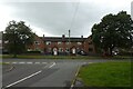
Third Avenue
Looking across Third Avenue from the end of Price Avenue.
Image: © DS Pugh
Taken: 5 Aug 2023
0.10 miles
3
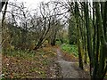
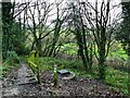
Path junction on the Brook Wood Trail
The trail runs through woodland for about 750m from Old Mill Road to Coronation Crescent.
Image: © Stephen Craven
Taken: 28 Dec 2021
0.11 miles
4

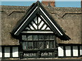
Sandbach Market
Sandbach has been a market town since the 16th century. Nowadays the Thursday market is still held outdoors and is sited around the Town Hall and on "Scotch Common".
Image: © Dennis Thorley
Taken: 14 Jul 2005
0.13 miles
5
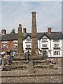
Sandbach Crosses
Two 9th century stone crosses, decorated on all faces with carved figures, animals and vine scrolls.
The taller cross shows biblical scenes and has a mutiliated head. The shorter cross has a truncated shaft with the mutilated head of another cross.
They were taken from their original site and broken up. The fragments were eventually restored to their present site in 1816.
The style and themes of the sculpture indicate contact with the wider Anglo-Saxon world, suggesting Sandbach was a significant centre of pre-Viking sculpture in the 9th century.
See http://www.megalithic.co.uk/article.php?sid=11101 for additional information.
Image: © Dennis Thorley
Taken: 14 Jul 2005
0.13 miles
7
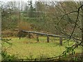
Sewer across the Dingle Brook
Shown just as 'pipeline' on large scale maps, this is undoubtedly a sewer, as there used to be a sewage works just south of this location, marked on the 1930s map but already shown as disused by the 1960s. The pipe now runs through the embankment of the A534 Wheelock Bypass, presumably to a pumping station somewhere the other side.
Image: © Stephen Craven
Taken: 28 Dec 2021
0.16 miles
8
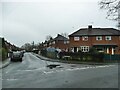
Latham Road, Sandbach
A side road off Coronation Crescent with post-War housing typical of this part of the town.
Image: © Stephen Craven
Taken: 28 Dec 2021
0.16 miles
9
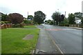
Bus stop on Crewe Road
The bus stop is listed as Sandbach Crewe Road / First Avenue.
Image: © DS Pugh
Taken: 5 Aug 2023
0.17 miles
10
Steps into Brook Wood
Steps off Coronation Crescent leading to the Brook Wood Trail, which runs for 750m from here to the edge of the town centre. The manhole cover to the right is probably on a sewer leading to the pipe across the brook Image
Image: © Stephen Craven
Taken: 28 Dec 2021
0.19 miles