IMAGES TAKEN NEAR TO
Crewe Road, SANDBACH, CW11 4NN
Introduction
This page details the photographs taken nearby to Crewe Road, CW11 4NN by members of the Geograph project.
The Geograph project started in 2005 with the aim of publishing, organising and preserving representative images for every square kilometre of Great Britain, Ireland and the Isle of Man.

There are currently over 7.5m images from over14,400 individuals and you can help contribute to the project by visiting https://www.geograph.org.uk
Image Map
Images are licensed for reuse under creativecommons.org/licenses/by-sa/2.0
Notes
- Clicking on the map will re-center to the selected point.
- The higher the marker number, the further away the image location is from the centre of the postcode.
Image Listing (178 Images Found)
Images are licensed for reuse under creativecommons.org/licenses/by-sa/2.0
Image
Details
Distance
1
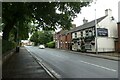
The Cricketers Arms
A pub on Crewe Road in Sandbach.
Image: © DS Pugh
Taken: 5 Aug 2023
0.00 miles
2
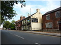
Cricketers Arms, Crewe Road, Sandbach
Image: © Alexander P Kapp
Taken: 28 Jul 2011
0.01 miles
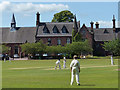
4
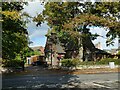
Sandbach School lodge
Dated to 1850, architect Sir George Gilbert Scott (along with the school to which it is the entrance, Image).
Image: © Stephen Craven
Taken: 15 Oct 2022
0.03 miles
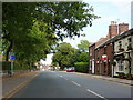
5
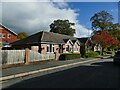
Belle Vue Terrace, Sandbach
Single-storey housing on the outskirts of the town centre.
Image: © Stephen Craven
Taken: 15 Oct 2022
0.04 miles
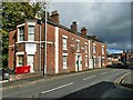
6
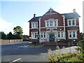
Sandbach House, Crewe Road
Formerly offices of the Sandbach Urban District Council. A planning application search shows that the property, then known as Woodlands, was refused an application in 1983 for demolition and building of flats. More recently it was used by Cheshire East Council (Care Services) but now by Sandbach School (boys' secondary school) for their sixth form.
Image: © Stephen Craven
Taken: 15 Oct 2022
0.04 miles
7
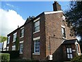
Dixon Rigby Keogh, Crewe Road, Sandbach
The firm of solicitors occupies a late 18th century house, listed grade II (entry 1330387). Stewrt Green's local history site says it was at one time a 'Dame School run by Mrs Worthington'.
Image: © Stephen Craven
Taken: 15 Oct 2022
0.06 miles
8
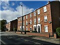
Modern town houses, Crewe Road, Sandbach
Along with the development behind called Sunnymill Drive, the housing occupies the site of the former ERF lorry factory.
Image: © Stephen Craven
Taken: 15 Oct 2022
0.06 miles
10
Harbour dental practice, Crewe Road, Sandbach
This has been a dental practice since before I first knew the town in 1977 although the name has changed. The practice occupies one of a row of grade II listed town houses (list entry 1330386).
Image: © Stephen Craven
Taken: 15 Oct 2022
0.09 miles