IMAGES TAKEN NEAR TO
Woodside Drive, SANDBACH, CW11 4JP
Introduction
This page details the photographs taken nearby to Woodside Drive, CW11 4JP by members of the Geograph project.
The Geograph project started in 2005 with the aim of publishing, organising and preserving representative images for every square kilometre of Great Britain, Ireland and the Isle of Man.

There are currently over 7.5m images from over14,400 individuals and you can help contribute to the project by visiting https://www.geograph.org.uk
Image Map
Images are licensed for reuse under creativecommons.org/licenses/by-sa/2.0
Notes
- Clicking on the map will re-center to the selected point.
- The higher the marker number, the further away the image location is from the centre of the postcode.
Image Listing (179 Images Found)
Images are licensed for reuse under creativecommons.org/licenses/by-sa/2.0
Image
Details
Distance
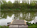
1
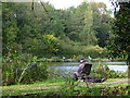
Dingle Lake from the south bank
The new path on this side of the brook gives a different perspective on the fishing lake. See Image for a view from the opposite bank.
Image: © Stephen Craven
Taken: 14 Oct 2017
0.06 miles
2
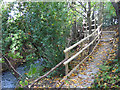
Path through Dingle Wood below the lake
At this point the bypass comes close to the stream, and there is barely room for the footpath in the remaining gap.
Image: © Stephen Craven
Taken: 14 Oct 2017
0.08 miles
3
Dingle Lake (2)
A heron stands on one of the (artificial?) islands in the lake.
Image: © Stephen Craven
Taken: 1 May 2010
0.08 miles
4
Dingle Lake (1)
Dingle Lake, or The Dingle, used to be a publicly accessible pond, but appears now to be private property belonging to an angling club.
Image: © Stephen Craven
Taken: 1 May 2010
0.09 miles
5
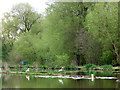
Dingle Lake (3)
One of the anglers' jetties on a private fishing lake. When I first knew this spot in the 1970s there was only countryside beyond it; now there is a bypass (with traffic visible in this photo) and newish housing beyond that (Woodside Drive according to the street map).
Image: © Stephen Craven
Taken: 1 May 2010
0.09 miles
6
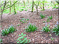
Bluebells near the Dingle
The first of May and bluebells are coming out in the woods on the west bank of the Dingle.
Image: © Stephen Craven
Taken: 1 May 2010
0.10 miles
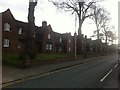
8
Almshouses, Newcastle Road
Like Sandbach School, Tall Chimneys (the Old Vicarage), the town's Literary Institution and Sandbach Heath C of E church, this row of Almshouses was the work of the prolific Victorian architect Sir George Gilbert Scott.
Image: © Chris Martyn
Taken: 9 Oct 2010
0.12 miles
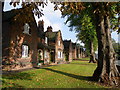
9
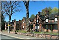
Sandbach Almshouses
In 1865, twenty Almshouses were built for the benefit of poor persons of good character resident in the ancient parish of Sandbach. Rules for occupation were strict. Residents had to attend church each Sunday and were not allowed to keep dogs or pigeons. Sir George Gilbert Scott designed the Almshouses and they cost £2,500 to build. They are listed Grade II.
Image: © Eirian Evans
Taken: 22 Apr 2021
0.12 miles
10
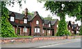
Almshouses - Newcastle Road, Sandbach
Image: © Anthony Parkes
Taken: 22 May 2014
0.12 miles