IMAGES TAKEN NEAR TO
Birch Gardens, SANDBACH, CW11 4HB
Introduction
This page details the photographs taken nearby to Birch Gardens, CW11 4HB by members of the Geograph project.
The Geograph project started in 2005 with the aim of publishing, organising and preserving representative images for every square kilometre of Great Britain, Ireland and the Isle of Man.

There are currently over 7.5m images from over14,400 individuals and you can help contribute to the project by visiting https://www.geograph.org.uk
Image Map
Images are licensed for reuse under creativecommons.org/licenses/by-sa/2.0
Notes
- Clicking on the map will re-center to the selected point.
- The higher the marker number, the further away the image location is from the centre of the postcode.
Image Listing (202 Images Found)
Images are licensed for reuse under creativecommons.org/licenses/by-sa/2.0
Image
Details
Distance
1
Sandbach Cemetery: new cremation area
A second facility for interments and memorial plaques, to replace the one that had become full Image
Image: © Stephen Craven
Taken: 19 Mar 2017
0.07 miles
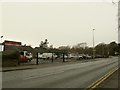
2
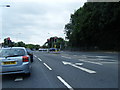
The junction of A535 and High Street, Sandbach
Image: © Ian S
Taken: 27 May 2011
0.07 miles
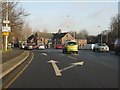
3

Crossroads in Sandbach
The bottom of High Street where it meets the A534.
Image: © Bill Boaden
Taken: 17 Aug 2019
0.07 miles
5
Premier Cars, Sandbach
At one time this was more of a car repair business (in the 1980's it was known by the name of its proprietor, Ron's garage), but it now concentrates on car sales.
Image: © Stephen Craven
Taken: 1 Jan 2016
0.08 miles
6
Sandbach - A534/ A533 junction
The Sandbach bypass meets the old route leading from High Street (left at the lights) toward Alsager.
Image: © Peter Whatley
Taken: 21 Jan 2011
0.08 miles
7
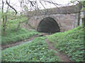
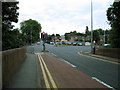
Sandbach Bridge
Sandbach (or Brook) Bridge is the crossing point of the Arclid Brook on the road from Sandbach to Alsager. According to one local website, it is said to be the site in AD653 of the baptism of Prince Peada, son of King Penda of Mercia. The present bridge dates from 1825 and is grade 2 listed.
Image: © Stephen Craven
Taken: 1 May 2010
0.08 miles
8
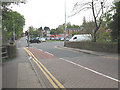
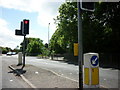
Sandbach Bridge and The Hill
For a history and side view of the bridge in the foreground, see Image This is a view looking east from the bottom of High Street, towards The Hill (the road towards Alsager rising up from the bridge - A533). In between is the traffic-light controlled junction with the A534 Sandbach Bypass, built in the 1980s. Since then the High Street has been made one-way westbound, with just a cycle contraflow lane as seen in the foreground.
Image: © Stephen Craven
Taken: 1 May 2010
0.08 miles
9
Cycle lane, Sandbach Bridge
The road across the bridge is now one-way (northbound i.e. towards the town centre) except for this contraflow cycle lane.
Image: © Stephen Craven
Taken: 21 Jul 2012
0.08 miles