IMAGES TAKEN NEAR TO
Dunham Close, SANDBACH, CW11 4EL
Introduction
This page details the photographs taken nearby to Dunham Close, CW11 4EL by members of the Geograph project.
The Geograph project started in 2005 with the aim of publishing, organising and preserving representative images for every square kilometre of Great Britain, Ireland and the Isle of Man.

There are currently over 7.5m images from over14,400 individuals and you can help contribute to the project by visiting https://www.geograph.org.uk
Image Map
Images are licensed for reuse under creativecommons.org/licenses/by-sa/2.0
Notes
- Clicking on the map will re-center to the selected point.
- The higher the marker number, the further away the image location is from the centre of the postcode.
Image Listing (380 Images Found)
Images are licensed for reuse under creativecommons.org/licenses/by-sa/2.0
Image
Details
Distance
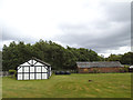
1
Dingle Farm, Sandbach
This 17th century farmhouse, listed grade 2, is surprisingly close to the town centre - 130m from the parish church, 300m from the town hall - yet retains a rural setting. I don't expect they actually farm any land now, though.
Image: © Stephen Craven
Taken: 1 May 2010
0.04 miles
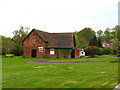
2
Mock timber-framed shed
The building on the left in this picture, in the grounds of Dingle Farm, may look to be traditionally timber framed but it was obvious from a closer look that it was built of contemporary concrete blockwork with the wood effect painted on.
Image: © Stephen Craven
Taken: 23 Jun 2013
0.04 miles
3
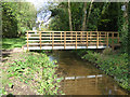
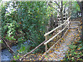
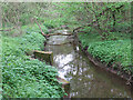
Bridge into Dingle Wood
The footbridge shown here, and the path leading to it, were installed in 2016.
Image: © Stephen Craven
Taken: 14 Oct 2017
0.05 miles
4
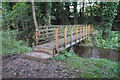
Footbridge in Dingle Wood
Crossing Mill Stream which links some of the Sandbach Flashes.
Image: © Bill Boaden
Taken: 17 Aug 2019
0.05 miles
6
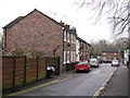
Church Street, Sandbach
A mixture of newer and older houses.
Image: © Stephen Craven
Taken: 23 Jun 2013
0.05 miles
7
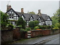
Houses in Front Street
Grade II listed 'black and white' 16th century timber frame building with 19th century restorations backing onto Church Street.
Image: © John M
Taken: 20 Oct 2017
0.05 miles
8
Path through Dingle Wood below the lake
At this point the bypass comes close to the stream, and there is barely room for the footpath in the remaining gap.
Image: © Stephen Craven
Taken: 14 Oct 2017
0.05 miles
9
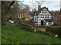
Front Street, Sandbach, with daffodils
The half-timbered house in this view, 22 Front Street, dates from the 17th century and is grade 2 listed (list entry 1130347).
Image: © Stephen Craven
Taken: 19 Mar 2017
0.05 miles
10
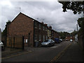
Front Street sewage overflow
At the bottom of Sandbach town centre, a water company plaque identifies this as the Front Street Storm Sewage Overflow. See http://www.dwrcymru.com/English/library/publications/CSO/english.pdf for a technical explanation.
Image: © Stephen Craven
Taken: 1 May 2010
0.06 miles