IMAGES TAKEN NEAR TO
White Hall Lane, SANDBACH, CW11 3QJ
Introduction
This page details the photographs taken nearby to White Hall Lane, CW11 3QJ by members of the Geograph project.
The Geograph project started in 2005 with the aim of publishing, organising and preserving representative images for every square kilometre of Great Britain, Ireland and the Isle of Man.

There are currently over 7.5m images from over14,400 individuals and you can help contribute to the project by visiting https://www.geograph.org.uk
Image Map
Images are licensed for reuse under creativecommons.org/licenses/by-sa/2.0
Notes
- Clicking on the map will re-center to the selected point.
- The higher the marker number, the further away the image location is from the centre of the postcode.
Image Listing (6 Images Found)
Images are licensed for reuse under creativecommons.org/licenses/by-sa/2.0
Image
Details
Distance

2
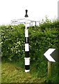
Old Direction Sign - Signpost by White Hall Lane, Warmingham Parish
Pawn finial - 3 arms; Cheshire CCC octagonal in parish of Warmingham (Crewe And Nantwich District), White Hall Lane junction with Crabmill Lane.
To be surveyed
Milestone Society National ID: CH_SJ7161B.
Image: © Milestone Society
Taken: Unknown
0.18 miles
3
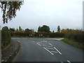
Minor road junction on School Lane, Warmingham
Image: © JThomas
Taken: 29 Oct 2016
0.19 miles
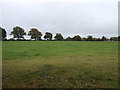
5
Contrasting Signpost Styles, Dragon's Lane Crossroads
The older signpost has been sadly neglected, despite having modern boards attached. For a well-maintained example, see http://www.geograph.org.uk/photo/1678401.
Image: © Peter Whatley
Taken: 19 Jan 2010
0.24 miles
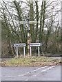
6
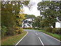
Sharp bend in Dragon's Lane
National cycle route 5 heading south east.
Image: © JThomas
Taken: 29 Oct 2016
0.25 miles