IMAGES TAKEN NEAR TO
Dragons Lane, SANDBACH, CW11 3QH
Introduction
This page details the photographs taken nearby to Dragons Lane, CW11 3QH by members of the Geograph project.
The Geograph project started in 2005 with the aim of publishing, organising and preserving representative images for every square kilometre of Great Britain, Ireland and the Isle of Man.

There are currently over 7.5m images from over14,400 individuals and you can help contribute to the project by visiting https://www.geograph.org.uk
Image Map
Images are licensed for reuse under creativecommons.org/licenses/by-sa/2.0
Notes
- Clicking on the map will re-center to the selected point.
- The higher the marker number, the further away the image location is from the centre of the postcode.
Image Listing (4 Images Found)
Images are licensed for reuse under creativecommons.org/licenses/by-sa/2.0
Image
Details
Distance
1
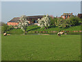
Sparrowgrove, Dragon's Lane
The farmstead viewed across the 'flash' (a local term for a lake formed where land has subsided above a salt mine).
Image: © Stephen Craven
Taken: 19 Apr 2009
0.01 miles
2
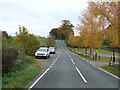
National Cycle Route 5
Dragon's Lane heading east.
Image: © JThomas
Taken: 29 Oct 2016
0.12 miles
3
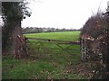
Field gate near Moston
Typical low lying pasture land of the Cheshire Plain
Image: © Gill Stott
Taken: 2 Jan 2007
0.16 miles
4
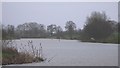
Moston Flash
Moston Flash is a naturally occurring flooded linear valley created by the solution of underlying salt deposits and subsidence of the land above. The process has been enhanced by salt extraction at the nearby saltworks. The linear lakes contain some unusual plants and animals because of the presence of saline (salty) water, they are also important areas for wildfowl and wader birds, and recreational fishing. The area is protected and managed as a Site of Special Scientific Interest.
Image: © Gill Stott
Taken: 2 Jan 2007
0.20 miles