IMAGES TAKEN NEAR TO
Chaucer Grove, SANDBACH, CW11 3NP
Introduction
This page details the photographs taken nearby to Chaucer Grove, CW11 3NP by members of the Geograph project.
The Geograph project started in 2005 with the aim of publishing, organising and preserving representative images for every square kilometre of Great Britain, Ireland and the Isle of Man.

There are currently over 7.5m images from over14,400 individuals and you can help contribute to the project by visiting https://www.geograph.org.uk
Image Map
Images are licensed for reuse under creativecommons.org/licenses/by-sa/2.0
Notes
- Clicking on the map will re-center to the selected point.
- The higher the marker number, the further away the image location is from the centre of the postcode.
Image Listing (72 Images Found)
Images are licensed for reuse under creativecommons.org/licenses/by-sa/2.0
Image
Details
Distance
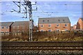
1
Railway bridge over Hall Lane
Actually a pair of bridges, the nearer brick arch (with a height limit of 3.7m) carrying the freight lines between Middlewich and Crewe, and the further, modern extension taking the fast lines between Manchester and Crewe. See Image for the other side.
Image: © Stephen Craven
Taken: 28 Oct 2024
0.05 miles
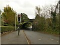
2
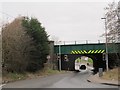
Hall Lane railway bridge, Elworth
Actually a pair of bridges, the nearer modern steel bridge carrying the fast lines between Manchester and Crewe, and the older brick arch beyond (with a height limit of 3.7m) carrying the freight lines between Middlewich and Crewe. The presence of a sharp bend just beyond necessitates traffic light control.
Image: © Stephen Craven
Taken: 19 Mar 2016
0.05 miles
4
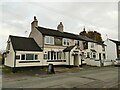
The Rookery Tavern, Elton Road, Elworth
The pub is named after the nearby railway and canal bridges, or possibly vice-versa. It had recently reopened (August 2024) as a free house, after some time as a tied pub.
Image: © Stephen Craven
Taken: 28 Oct 2024
0.06 miles
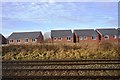
6
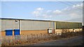
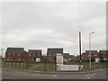
Canal Fields, Ettiley Heath (2)
An infill housing development built around 2014-5 between the canal and railway. See also Image See Image for the bone and manure works that previously occupied this "brownfield" site.
To the right is the railway bridge seen from the other side in Image
Image: © Stephen Craven
Taken: 19 Mar 2016
0.06 miles
8
Canal Fields, Ettiley Heath
An infill housing development built around 2014-5 between the canal and railway. See also Image See Image for the bone and manure works that previously occupied this "brownfield" site.
Image: © Stephen Craven
Taken: 19 Mar 2016
0.08 miles
9
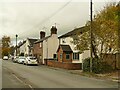
Old cottages, Elton Road, Elworth
Possibly the oldest houses in the area; certainly shown on the 1898 map.
Image: © Stephen Craven
Taken: 28 Oct 2024
0.08 miles