IMAGES TAKEN NEAR TO
Warmingham Grange Lane, SANDBACH, CW11 3LB
Introduction
This page details the photographs taken nearby to Warmingham Grange Lane, CW11 3LB by members of the Geograph project.
The Geograph project started in 2005 with the aim of publishing, organising and preserving representative images for every square kilometre of Great Britain, Ireland and the Isle of Man.

There are currently over 7.5m images from over14,400 individuals and you can help contribute to the project by visiting https://www.geograph.org.uk
Image Map
Images are licensed for reuse under creativecommons.org/licenses/by-sa/2.0
Notes
- Clicking on the map will re-center to the selected point.
- The higher the marker number, the further away the image location is from the centre of the postcode.
Image Listing (3 Images Found)
Images are licensed for reuse under creativecommons.org/licenses/by-sa/2.0
Image
Details
Distance
1
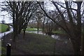
River Wheelock
Swollen with winter rains, the Wheelock is nearly out of its bounds today
Image: © Bob Harvey
Taken: 8 Feb 2019
0.19 miles
2
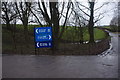
Private road signs
Road signs for the private roads on Hilltop and Hole House farms, where salt caverns are used to extract salt, and later for the storage of natural gas. Both farms are still run normally as dairy farms.
Image: © Bob Harvey
Taken: 8 Feb 2019
0.23 miles
3
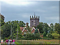
Warmingham: St. Leonard's church and cottages
Warmingham: St. Leonard's church and cottages from the drive to Hill Top Farm. For a closer view of the church see Image
Image: © Mike Harris
Taken: 27 Sep 2006
0.25 miles